Island Peak Climbing
Peak Climbing

Island Peak Climbing

Book Now

Other Packages

Trip Facts

  • Max Altitude 6189m
  • Grade Adventurous
  • Duration 19 Days
  • Group Size 2 - 15

Overview

Island Peak Climbing offers an experience of a lifetime, a complete adventure with a classic mountain of Himalaya at 6,160 meters as per the standard height of NMA (Nepal Mountaineering Association) where all the permission and climbing permits are obtained.

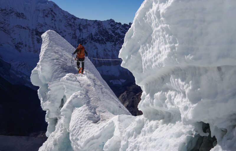
The Island Peak Climbing is straightforward with some technical sections in the beginning and near to the summit, where our expert guide will make necessary arrangements to make the climb safe and possible, the climbing grade PD + as per French and Swiss alpine system

On this Island Peak Trek/ Imjatse Peak 6,160 m marvel the scenery from Mt. Everest (8,848m / 29, 028ft) Lhotse (8,516 m-24,940 ft), Nuptse (7,855m-25,772 ft) and Lho – La or Khumbutse peak (6,036 m – 19,992ft) Mt. Lingtren (6,749 m / 22,142 ft) Chnagtse ( 7,583 m / 25,230 ft) Mt. Pumori (7,161 m / 25,772 ft) Ama Dablam ( 6,812 m / 22,480 ft) Kangtenga (6,782 m / 22, 380 ft) Tharmarserku ( 6,623 m / 21, 855 ft) Kwangde (6,011 m / 19,837 ft) Kusum Khanguru (6,373 m / 21,030 ft) holy peak of Khumbi-la (5,761 m / 19,012 ft) and as far world’s 5th highest Mt. Makalu (8,463 m / 27, 766 ft) with Island Peak / Imjatse (6,160 m / 20,328ft) Lobuje Peak (6,119 m / 20,192 ft) Pokhalde ( 5,806 m / 19,159 ft) and many other smaller unnamed peaks.
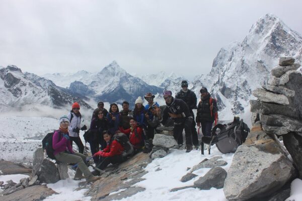
Island Peak climbing with Kalapatthar is one of the most popular and trekked regions due to its easy accessibility from the small airstrip at Lukla, trek, and climb of Island / Imjatse Peak concludes at the picturesque touristic town at Lukla, the trek is moderate in the beginning and to adventurous where all types of travelers can join in this wonderful walking journey and the time duration taking just a little more than 2 weeks in the comfort of warm cozy lodge known as tea houses along the route and camping service on the climb for few days.

Island Peak Climbing or Imjatse Peak 6,160 m is the second busiest trekking destination after Annapurna region, one of the most unique journeys leading from rich vegetation of mid-hills to arctic landscapes and climate zone, all these drastic changes in temperature found only in the high valleys and mountains of Khumbu area with a dramatic change in vegetations and its awesome scenery.

This trek and climb leads through many traditional Sherpa villages famous as mountaineers and warm hospitality and has been high altitude porters and guides for the last five decades.

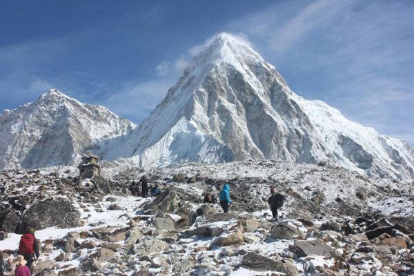
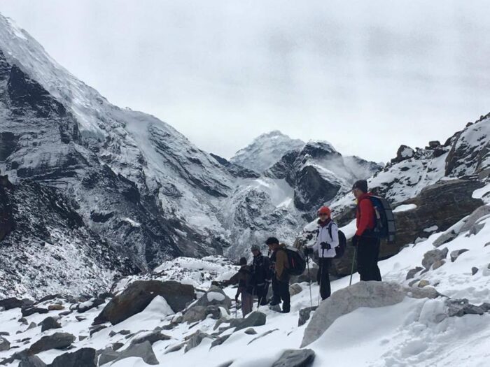
This remarkable trek starts from Lukla the gateway to Everest area and then over to the famous Namche Bazaar at 3,440 meters and then with rest day for proper acclimatization and then heading higher to Imjatse valley through the scenic spot of Tengboche Monastery and Pangboche then finally reaching our destination at world’s highest Mountain base camp at 5, 364 meters and then climb up to Kalapathar the highest point at 5,545 meters and then to the highlight of this adventure towards the end of Imjatse valley for the classic climb to the summit of Island / Imjatse peak at 6,160 meters high offering a tremendous panorama of surrounding high snow-capped peaks and valleys, on the climb our expert guide will support you all the way to the summit top, and then slowly with a scenic walk ending this beautiful and awesome trek concluding this adventure back at Lukla for the flight back to Kathmandu after a great experience of a lifetime with wonderful memories of island peak climbing.

Itinerary

Day 01

Arrival in Kathmandu (1345m/4412ft) and transfer to respective hotels

On reaching Kathmandu airport meet the guide and staff for the transfer to respective hotels around Thamel area, with rendezvous with other members of the group for orientation and briefing with welcome dinner at authentic Nepali dinner.

  • Max. Altitude
    1345m/4412ft
  • Accomodation
    3 stars level hotel
Day 02

An early morning to Lukla from Kathmandu and trek to Phakding (2610mtrs/8563ft). Flight 30 minutes and walking 3 hours

Morning transfer to Kathmandu domestic airport for a short scenic flight of 35 minutes to Lukla the gateway to Everest and higher Khumbu area, from here after a break to refresh meet the guide, trekking staff and porters and continue to walk past Lukla town on the easy path with views of Kwangde peak and village of Muse and Chowri Kharka, the walk with few ups and down following the Dudh Kosi River passing villages of Choplung, Ghat till Phakding is reached for an overnight stop.

  • Max. Altitude
    2610mtrs/8563ft
  • Meal
    Breakfast/ Lunch/Dinner
  • Accomodation
    Hotel/Tea house
Day 03

Phakding to Namche Bazaar (3440m/11286ft). Walking 5:30 hours.

From Phakding morning walk is pleasant through nice woodland of pines and rhododendron trees with few ups and down with views of Kusum Khanguru, Kwangde and Tharmasarku peaks crossing the bridge over Dudh Kosi to reach Monjo and to Jorsalle after the entrance of Sagarmatha National Park, at Jorsalle for lunch. From here walking on the riverbed for some time and heading uphill in the forest to cross the last bridge over Imjatse and Bhote Kosi that joins Dudh Kosi river at this point. A long winding uphill with first views of Mt. Everest, Lhotse, and Nuptse (on a clear day) this winding climb finally reaches Namche Bazaar after a few hours of hard uphill walk from lunch place. At Namche check into one of the fine designated lodges with time to browse around the shops and vendors or just relax.

  • Max. Altitude
    3440m/11286ft
  • Meal
    Breakfast/ Lunch/Dinner
  • Accomodation
    Hotel/Tea house
Day 04

Rest and Acclimatization. This day visit Khumjung village (3790m) and Everest view hotel and trek back to Namche Bazzar (3440m/11286ft). Walking 5:30 hours.

A great place for rest and free day and necessary for acclimatization before heading higher beyond Namche, at Namche optional short hike to a viewpoint and the museum provides information of this area from flora/fauna, geography, mountain and Sherpa history, culture and religion offering tremendous views of Everest, Lhotse, Nuptse, Ama Dablam, Thermasarku, Kwangde, holy Khumbi-la peak and of valley and gorge below. Optional hike to Everest View Hotel above Namche at 3,880 meters by Syangboche old airstrip or a half-day hike visiting the quiet and sleepy villages of Khumjung with monastery and Khunde.

  • Max. Altitude
    3440m/11286ft
  • Meal
    Breakfast/ Lunch/Dinner
  • Accomodation
    Hotel/Tea house
Day 05

Namche Bazzar to Debuche (3680m/12070ft) via Tenbuche monastery. Walking 5:30 s.

After an enjoyable rest at Namche, the journey continues on the nice and scenic trail with views of Mt. Everest, Ama Dablam, and other range of peaks walking into green tree lines a good walk with downhill to Phungetenga a small place in a gorge after crossing the Imjatse River for lunch at Phungetenga. From here a steep uphill haul through the nice forest surrounding with views of Thermasarku and Kangtenga peaks, and then with a long climb of fewer than two hours reaching at famous Tengboche monastery with awesome views of surrounding peaks including Mt. Everest and Ama Dablam. Here as per the time set for a visit inside the monastery where you can observe monks, priests, and lama on prayer time in the late afternoon. All major expeditions to Mt. Everest and other high peaks visit here to get a blessing from the high priest for a successful and safe climb. Then we continue trek to Debuche.

  • Max. Altitude
    3680m/12070ft 
  • Meal
    Breakfast/ Lunch/Dinner
  • Accomodation
    Hotel/Tea house
Day 06

Debuche to Dingboche (4410m/14464ft) via Panbuche - 05 hrs.

On leaving Debuche walk leads through the nice cool woodland passing to reach a bridge over Imjatse river gorge, from this bridge the last of trees lines and lush vegetation, walk leads to a gradual climb through rows of prayer and mani wall, stupa with fantastic views of Ama Dablam as the walk progress reaching Pangboche (the last permanent village on route Everest Base camp and another high area of Khumbu).
From Pangboche walk leads to a short steep climb to Shomare a small temporary village serving as a lodge, teahouse, and popular lunch stop on route Dingboche and Pheriche with close views of AmaDablam.
From here a slow climb towards Orsho where the walk gets gentle and the path splits from this place the other high trail to Pheriche, the lower path east to Dingboche, our route heading east crossing the icy Khumbu river tributary of Imjatse and Dudh Kosi river, and then a steep climb for 45 minutes to reach the ridge with prayer stones, a pleasant walk from here brings at Dingboche with many lodges around where the areas are guarded with stone walls located on the southern Imajatse valley beneath the towering North Face of Ama Dablam with views of Lhotse, peak 29 and Island / Imjatse peak towards east.

  • Max. Altitude
    4410m/14464ft 
  • Meal
    Breakfast/ Lunch/Dinner
  • Accomodation
    Hotel/Tea house
Day 07

Day hiking up to Nagatsang Ri (5000m/16500ft) and back to Dingboche( 4410m/14464ft).   Walking 4:25 hours.

A pleasant place for an extra rest day before starting the real adventure crossing passes of Khongmatse and Tsho-la, here optional hike to Nangkartsang a high hill offering superb views of surrounding snow-capped peaks including world 5th highest Mt. Makalu and Amphu Labtsa peaks as well. Rest of the afternoon at leisure the last place with an assist to cybercafé in one its many lodges around.

  • Max. Altitude
    4410m/14464ft 
  • Meal
    Breakfast/ Lunch/Dinner
  • Accomodation
    Hotel/Tea house
Day 08

Dinbuche to Lobuche (4910m/16104ft ) via Thugla 4,640 m - 05 hrs.

Starting the morning walk with a slow climb uphill to the ridge with prayer flags and Buddhist monument of the stupa, overlooking superb views of snow-capped peaks and on the pleasant trail with gradual up and downhill reaching the raging streams fed from the Khumbu glacier at a small place of Thugla (Dugla). A popular lunch stop place where the trail from Pheriche and Dingboche joins with an hour break a steep climb of less than an hour reaches the top ridge of Thug-la with great views of Ama Dablam north face with Tawache and Cholatse, an interesting spot with memorials of late mountaineers who died climbing Everest, Lhotse, Pumori or other peaks of this area. From here the walk continues on the gradual path towards Lobuche in the comfort of a nice cozy lodge after a good day.

  • Max. Altitude
    4910m/16104ft
  • Meal
    Breakfast/ Lunch/Dinner
  • Accomodation
    Hotel/Tea house
Day 09

Lobuje to Everest Base Camp (5363m/17595ft) and back to Gorak Shep(5153m/16906ft). – walking 7:30 hours,

Today we reach our goal by trekking to Everest Base Camp at an altitude of 5363m. After appreciating our efforts and photographing the achievement we return to Gorak Shep.

  • Max. Altitude
    5153m/16901ft   
  • Meal
      Breakfast/ Lunch/Dinner
  • Accomodation
    Hotel/Tea house 
Day 10

Hiking up Kalapathar(5555m/18192ft) and trek down to Dinbuche (4410m/14464ft). 6:30 hours

From our base at Gorak Shep we continue to climb this time hiking up Kalapathar. Leaving as early as possible to take advantage of the morning light, the panoramic views of Everest and the surrounding mountains, as we reach our destination of the Kalapathar viewpoint. Following this we descend to Dinbuche.

  • Max. Altitude
    4410m/14464ft
  • Meal
    Breakfast/ Lunch/Dinner
  • Accomodation
     Hotel/Tea house
Day 11

Trek to Island Peak Base Camp (5050m/ 16565ft) - 4:30 hrs.

The route to Base Camp, the path at first climbs quite steeply to the south before following the moraine east along the main valley below the southern or true left bank of the Lhotse Glacier. The trail then follows glacial streams to the snout of the Imja glacier. At this point, the path swings northeast and crosses a dried-up lake bed between the Lhotse and Imja Glaciers, from a base camp at Pareshaya Grab. A well-acclimatized party in good condition can make the summit and return in a day back to Base Camp.

  • Max. Altitude
    5050m/ 16565ft
  • Meal
    Breakfast/ Lunch/Dinner
  • Accomodation
    Tented camp
Day 12

Rest and acclimatization at Island peak base camp (5050m/16565ft) and preparations for climbing. .

A necessary rest or free day for acclimatization with preparations sorting out gear for the climb, afternoon short hike around on this beautiful surrounding enclosed with snow capped peaks.

  • Max. Altitude
    5050m/16565ft
  • Meal
    Breakfast/ Lunch/Dinner
  • Accomodation
    Tented camp
Day 13

Extra day, in case of the weather.

This is an additional day in the itinerary to compensate for any possible delays on the trekking/ climbing or cancellation of the flights. We extremely recommend that you have at least 2 extra days after the itinerary so as to maintain any possible delays or cancellation of the flight. If everything goes without any problem, you can utilize those extra days doing some other activities.

  • Max. Altitude
    5050m/ 16565ft
  • Meal
    Breakfast/ Lunch/Dinner
  • Accomodation
    Tented camp
Day 14

Island peak summit (6189m/20305ft) and back to base camp (5050m/ 16565ft)

A Big Day! Starting before dawn after having breakfast and then scrambling up an open gully leads between two well-defined ridges of a small hanging glacier at 5,280m /17,323ft. Care should be taken to avoid possible avalanche danger from the ice above.
From this point of left-hand ridge scramble across the broad open gully and gain the right-hand ridge. Following this, this gives easy scrambling to the snow-covered glacier above. A route needs to be found out leftwards, avoiding seracs and crevasses before turning back northwards over snow-covered scree in the margin between the glacier and the base of the main summit ridge. After crossing a gully with some stone and icefall danger, a steep snow and ice ramp leads upwards for nearly 100 meters (300ft), to the summit ridge. The last moves on to the ridge often prove difficult and many climbers leave a fixed rope in place to aid descent. The ridge itself is a classic and undulates towards the main summit which is reached by a final tricky snow pitch. Standing atop we have the stunning close-up view of the South face of Lhotse (8,501 m.) in the vastness that looms before us. We have impressive dramatic views of the mountains -Amadablam (6,856 m.), Chamlang, and Baruntse on the far horizon. Descent is made by the same route to the base camp.

  • Max. Altitude
    5050m/ 16565ft
  • Meal
    Breakfast/ Lunch/Dinner
  • Accomodation
    Tented camp
Day 15

Island peak base camp to Kyanjuma (3490m/11447ft). Walking 7 hours

Today’s part of the trek is, even more, easier as we will be walking gently for only five hours along with the solitary company of deep woods. We will first reach the village of Pangboche from where we will get a beautiful view of the Dudh Koshi river basin below.

We will bid farewell to the Sagarmatha National Park just before reaching Namche Bazaar as we exit from the park entrance/exit gate. The rest of the trek is a glorious walk to Namche Bazaar with a 360 view of the mountains on all sides.

  • Max. Altitude
    3490m/11447ft
  • Meal
    Breakfast/ Lunch/Dinner
  • Accomodation
    Hotel/Tea house
Day 16

Kyanjuma to Jorsalle (2950m/9676ft) via Namche Bazzar. Walking 5 hours.

This is second last day in the Everest region. We will see many Sherpa villages on our way being the largest. There are many monasteries, stupas, prayer flags, and prayer walls in and around these villages.

The houses in the village are close together to keep the community warm and are impeccably clean. The Sherpa people are very friendly and well-known mountaineers.

  • Max. Altitude
    2950m/9676ft
  • Meal
    Breakfast/ Lunch/Dinner
  • Accomodation
    Hotel/Tea house
Day 17

Jorsalle to Lukla. (2850m/9348ft). Walking 4:30 hours

The last day walk of this adventure to Lukla, the path follows the Dudh Kosi for some time passing Benkar, Tuc Tuc, and Phakding villages, and then slowly reaching Choplung where the trail from Jiri and Lukla joins.
From here the last 50 minutes climb of this trip to Lukla, on reaching Lukla in the comfort of a nice lodge and preparing for the last night’s dinner and party with fellow trekking guides, staff, and porters.

  • Max. Altitude
    2850m/9348ft
  • Meal
    Breakfast/ Lunch/Dinner
  • Accomodation
    Hotel/Tea house
Day 18

After breakfast an early morning flight back to Kathmandu (1345m/4412ft) from Lukla and transfer to the hotel at 3 stars level, inclusive breakfast. Flight time 30 minutes.

Morning as per the flight schedule transfer to Tenzing, Hillary airport, Lukla for the scenic short flight back to Kathmandu with parallel views of snow-capped mountains all the way to Kathmandu, on reaching the airport transfer to respective hotels around Thamel area, with rest of the afternoon free at leisure.

  • Max. Altitude
    1345m/4412ft
  • Meal
    Breakfast/ Dinner
  • Accomodation
    3 stars level hotel
Day 19

International departure to respective countries

The trip ends, our Airport Representative will drop you to the Kathmandu international airport for your final flight departure from Nepal. Driving 15 km – 10 minutes

  • Meal
    Breakfast

Pricing

Price for Island Peak Climbing in different currency as follows:

Currency Pricing USD Euro AUD CAD Indian Rupees
Price per person USD 2775 2,469 4,021 3,609 206.403

WANT TO KNOW LATEST DEALS ?
For latest offers & pricing for group & individual, please contact us.

Service Includes and Excludes

Service Included in this Trip

  • All the ground transportation by car.
  • Hotel accommodation in Kathmandu with breakfast at 3 to 4 stars level.
  • Meals on full board (Breakfast, lunch and dinner) in trekking and climbing period for you. (Sample of trekking Menu)
  • Seasonable Local fresh fruits.
  • Filtered water in trekking using (Katadyn Pocket Water Filter).
  • Twin sharing comfortable private room in trekking part and tented camp in climbing part.
  • Trip map.
  • Domestic flight tickets from Kathmandu/ Lukla/ Kathmandu with airport tax.
  • An experienced government licensed holder guide and porters to carry your luggage during the trek.
  • Food, drinks, accommodation, insurance, salary, equipment’s, transportation, local tax for Guide and porters.
  • All necessary camping gears like two men tent, kitchen tent, kitchen equipment, mattress while climbing period.
  • Group medical supplies (first aid kit will be available).
  • All necessary paper works and national park entry permits.
  • Pasang Lammu rural municipality entry fee.
  • Climbing permit.
  • Token of trip achievement award certificate as a Souvenir. (Sample of Certificate)
  • Climbing equipment like ice axe, Ice crew, snow bar, climbing rope.
  • Emergency helicopter rescue arrangement which will be paid by your insurance company.
  • TIMS (Trekkers’ Information Management System).
  • All our government taxes, vat, local tax, tourist service charges.

Service Excluded in this Trip

  • Lunch and dinner in Kathmandu.
  • All kind drinks (Alcoholic, hot and cold drinks) in mountain.
  • Personal equipment.
  • International airfare to and from Kathmandu.
  • Travel and rescue insurance.
  • Extra personal expenses (phone calls, laundry, bar bills, battery recharge, laundry, shower, excess baggage charges).
  • Personal climbing equipment’s ( Joomer, carabiner lock, carabiner unlock, Harnex belt, Eight finger, helmet, gaiters, Boots, crampons).
  • Tips for trekking staff and driver (Tipping is expected).
  • Any others expenses which are not mentioned on ‘Price Includes’ section.

Fixed Departure

Year
  • 2023
  • 2024
Start Date End Date Availability Booking
30 Sep, 2023 17 Oct, 2023 OPEN Book Now
30 Sep, 2023 18 Oct, 2023 OPEN Book Now
02 Oct, 2023 20 Oct, 2023 OPEN Book Now
02 Oct, 2023 21 Oct, 2023 OPEN Book Now
09 Oct, 2023 27 Oct, 2023 OPEN Book Now
09 Oct, 2023 28 Oct, 2023 OPEN Book Now
16 Oct, 2023 04 Nov, 2023 OPEN Book Now
16 Oct, 2023 05 Nov, 2023 OPEN Book Now
23 Oct, 2023 11 Nov, 2023 OPEN Book Now
23 Oct, 2023 12 Nov, 2023 OPEN Book Now
30 Oct, 2023 19 Nov, 2023 OPEN Book Now
31 Oct, 2023 18 Nov, 2023 OPEN Book Now
02 Nov, 2023 20 Nov, 2023 OPEN Book Now
02 Nov, 2023 21 Nov, 2023 OPEN Book Now
09 Nov, 2023 27 Nov, 2023 OPEN Book Now
09 Nov, 2023 28 Nov, 2023 OPEN Book Now
16 Nov, 2023 03 Dec, 2023 OPEN Book Now
16 Nov, 2023 05 Dec, 2023 OPEN Book Now
23 Nov, 2023 10 Dec, 2023 OPEN Book Now
23 Nov, 2023 12 Dec, 2023 OPEN Book Now
30 Nov, 2023 17 Dec, 2023 OPEN Book Now
30 Nov, 2023 18 Dec, 2023 OPEN Book Now
02 Dec, 2023 20 Dec, 2023 OPEN Book Now
02 Dec, 2023 22 Dec, 2023 OPEN Book Now
09 Dec, 2023 20 Dec, 2023 OPEN Book Now
09 Dec, 2023 28 Dec, 2023 OPEN Book Now
16 Dec, 2023 04 Jan, 2024 OPEN Book Now
16 Dec, 2023 05 Jan, 2024 OPEN Book Now
23 Dec, 2023 11 Jan, 2024 OPEN Book Now
23 Dec, 2023 12 Jan, 2024 OPEN Book Now
30 Dec, 2023 18 Jan, 2024 OPEN Book Now
30 Dec, 2023 19 Jan, 2024 OPEN Book Now

Does our itinerary plan do not go with your holiday dates? Does fixed departure dates are not suitable for you? Do you want to extend or shorten your trip duration? No worries, we can create your own custom tailor-made holidays with flexible duration and dates.
Click here to share your plan with us.

Trip Info

Our Island Peak Climbing route journey begins with a scenic flight to Lukla over a lush valley. After landing at one of the most dangerous airports in the world, we begin our journey by trekking to Pak Din and arrive at Namche Bazaar. Then trek through traditional Sherpa villages such as Tengboche, Pangboche and Dingboche to reach Everest Base Camp. On the way to Island Peak Base Camp, spectacular mountains accompany us during a trek.

As the trail passes through the Khumbu region, also known as the Sherpa land, we have the opportunity to enjoy local traditions, customs, dance and culture. Climbing Island Peak in Nepal is considered one of the most attractive extensions in the Everest region. The mountain itself is believed to be an extension of the southern ridge of Lhotse Shar. Located on the Chukun Glacier between Ama Dablam (6856m) and the Lhotse Mountains, Island Peak is one of the most popular trekking destinations for mountaineers and adventurous people due to its harsh geographical conditions. Climbing Island Peak 6189m does not require any technical climbing experience, but advanced fitness and willingness to push the limits is sufficient. The experience of climbing along the top of the island will be very challenging and exciting.

Frequently Asked Questions

When is the best time to visit Island Peak Climbing?

In Nepal, the suitable time for a visit to a high altitude is during the spring and autumn season. During this time of the year, the weather is suitable for any kind of visit. Similarly, it is the best time for climbing and trekking in Nepal and this time is also best for Island Peak Climbing. Furthermore, if you travel during the autumn season then you will experience the biggest festivals of the country Dashain and Tihar.

What are the difficulties of the Island Peak Climbing?

What are the essentials for the Island Peak Climbing?

What kind of weather and climate will I find on the Island Peak Climbing?

What kind of meal and accommodation facilities will I find on the Island Peak Climbing?

How fit should I be for the Island Peak Climbing and difficulty level of the climb?

Should I carry a first aid kit and personal medication on the Island Peak Climbing?

What are the safety and security measures on the Island Peak Climbing?

Can I carry children on the Island Peak Climbing with me?

Is safe drinking water available on the Island Peak Climbing?

Grade A: Easy *

Trekking is essentially day hiking and doesn’t require any special training. However, good physical condition, a love of walking, and a desire to enjoying the spectacular views of the mountains and encounter village life are essential. We offer a diverse range of easy treks. Categorizing a trek as easy means that no difficult climbing or ascents to high altitudes is involved. They take usually no more than a week and are suitable for anyone. Be assured that a loss of altitude in no way means a loss of interesting things to see and experience. While our more challenging treks get you closer to a small number of mountain ranges, lower altitude treks often provide better viewpoints from which to enjoy the colorful horizons of a whole series of ranges. The duration of a trek can be from 4 to 9 days with an average of 4 to 5 hours walking per day. The elevation of the trail will be between 800m/2624ft and 2800m/ 9240ft above sea level.

Grade B: Moderate **

These treks are suitable for any walker looking for something a little more challenging and energetic. They are a combination of some longer and shorter walks and hill-walking experience is desirable. The duration is usually from 10 to 15 days. Following the up and down terrain of Nepal and walking to higher elevations contrasts these treks to those in the easy classification. However, you will be rewarded for your efforts with spectacular close-up views of glaciers and of the high Himalayas. Although the terrain is not difficult, some vigorous hiking experience is useful. There may be up to 6 hours a day on the trail and the elevation rises and falls from 800m/ 2624ft to 4000m/13210ft above sea level.

Grade C: Fairly Strenuous ***

Since the terrain can be hard and the days long, hikers on these treks should be in good physical condition and have some previous mountain walking experience. Steep climbing may be involved, although it is never necessary to use ropes. Treks at this level can he arranged for periods of 16 to 21 days. Typically, a gradual ascent through a green river valley will lead you up to a number of high passes, where you will reach the altitude of 5416m. Often times, you will get a close insight into the Tibetan culture. Participants should except to trek above 5416m/17872ft.

Grade D: Strenuous ****

These real adventure treks are both technical and highly strenuous. Excellent physical condition is essential and mountaineering experience is preferable. Following rough terrain, they involve steep ascents to high altitudes with the possibility of some rope climbing. Stamina is needed to complete one of these treks, as it can take from 20 to 28 days to reach the heart of the wildernesses that they transverse. Participants should except to trek above 5600m/18480ft

EQUIPMENTS & GEARS

EQUIPMENTS, GEARS AND GUIDES

Nepal is one of the best places in the world for river rafting. Numerous fine rivers offer excellent opportunities for rafting, canoeing and simply immersing oneself in the magnificent landscape. Nepal’s thundering waters, coming from the glaciers of the mighty Himalayan, provide unmatched thrills.

Clothing

Down Or Fiber Filled Waterproof Jacket And Trousers 1
Fleece Jacket Or Pullover 1
Warm Cotton Trousers 2 Pairs
Shirts And T-Shirts 4 Pieces
Lightweight Cotton Long Pants 3 Pairs
Long Under Wear 2 Pieces
Short Under Wear 4 Pieces
Sun Hat Or Scarf 1
Woolen Hat 1
Sunglasses 1
Lightweight Gloves 1
Rain Coat 1
Heavyweight Gloves Or Mittens With A Waterproof 1

Footwear

Trekking Boot 1 Pair
Thick Socks 4 Pairs
Light Socks 3 Pairs
Camp Shoes 1 Pair
Sandals 1 Pair

Other Equipments

Sleeping Bag(4seasons) 1
Down Jacket 1
Daypack 1
Water Bottle 1
Sun Cream, Sunglasses
Flashlight With Spare Bulbs, Batteries, Lip Salve, Gaiters.

Optional

Insect Repellent Toilet Articles Note Book & Pen Toilet Roll
Laundry Soap Pocket Knife Towel Sewing Kit
Plasters Binoculars Camera Film
Cards And Personal Medical Kit

Travel insurance is compulsory for all Clients undertaking any tour. It should provide adequate protection for the full duration of the tour to cover personal injury, medical expenses, repatriation expenses, helicopter evacuation, loss of luggage, etc.

For your kind information, we would like to give a list of the insurance companies, please go through the links below:

For Canadians And Americans

  1. http://www.travelguard.com
  2. http://www.worldnomads.com
  3. http://www.mondial-assistance.ca
  4. http://www.travelassistnetwork.com
  5. http://www.travelex-insurance.com
  6. http://www.travelite.com
  7. http://www.travelunderwriters.com
  8. http://www.hccmis.com/atlas-travel-insurance

For Australians And New Zealanders

  1. http://www.covermore.com.au
  2. http://www.allianz.com.au
  3. http://www.worldnomads.com.au
  4. http://www.bupa.com.au
  5. http://www.itrektravelinsurance.com.au
  6. http://www.1cover.com.au

For British

  1. http://www.travel-guard.co.uk
  2. http://www.worldnomads.co.uk
  3. http://www.thebmc.co.uk
  4. http://www.direct-travel.co.uk
  5. http://www.essentialtravel.co.uk

For Europe And Slovenia

  1. http://www.coris.si
  2. http://www.europaeische.at

For South-Africa

  1. http://www.travel-guard.co.za
  2. http://www.tic.co.za

For Indians

  1. http://www.internationalsos.com/en/asia-pacific_india.htm

Acute Mountain Sickness (AMS) is common at high altitudes sickness. In general may occur when people ascend too quickly normally in altitudes of over 3000 m. The symptoms of altitude sickness are due to lower air pressure at high altitudes, which results in lower oxygen levels as you breathe the air in. The air is under less pressure and this makes it harder for your body to get the oxygen out of the air and into the circulation. It’s this extra strain on the body that causes altitude sickness.

Symptoms tend to be worse at night and include headache, dizziness, and lethargy, loss of appetite, nausea, breathlessness and irritability. Difficulty sleeping is another common symptom.

MAJOR SYMPTOMS OF ALTITUDE SICKNESS

INITIAL SYMPTOMS

  1. Periods of sleeplessness
  2. Runny nose.
  3. Extra tiredness
  4. Occasional loss of appetite
  5. Feeling laziness
  6. Wish to vomiting
  7. Periodic breathing

Above are normal symptoms which may occur into your body that you should not be worried. Every trekker will experience some or all of these, no matter how slowly they ascend.

ADVANCE SYMPTOMS

  1. Headache and vomiting
  2. Dizziness
  3. Racing heartbeat
  4. Exhaustion
  5. Nausea
  6. Diarrhoea
  7. Loss of apatite
  8. Weakness
  9. Hard to breath
  10. Extra tired
  11. Dry Raspy cough
  12. Sleeplessness

When above symptoms will occur into your body, these symptoms usually resolve by spending one or two extra nights at the same altitude or using medicine. Even you are resting at the same altitude or using medicine, if symptoms are becoming worse, then it is necessary to descend.

SERIOUS SYMPTOMS

  1. Worsening headache and vomiting
  2. Swelling of hands and face
  3. Reduced urine output
  4. Walking with a staggering gait
  5. Confusion
  6. Increased tiredness
  7. Breathing irregularity
  8. Visual hallucinations (seeing things that are not real)
  9. Changes in the ability to think
  10. Changes in normal behavior

If above serious symptoms will occur into your body, these extremely dangerous symptoms are called High Altitude Cerebral Edema (or HACE). They can lead to unconsciousness and death within 12 hours. Increasing shortness of breath, cough and tiredness may also be signs of High Altitude Pulmonary Edema or HAPE. HAPE can also be rapidly fatal if ignored.

TO PREVENT ACUTE MOUNTAIN SICKNESS

  1. If possible, don’t fly or drive to high altitude. Start below 3,000 metres (10,000 feet) and walk up.
  2. If you do fly or drive, do not overexert yourself or move higher for the first 24 hours.
  3. If you go above 3,000 metres (10,000 feet), only increase your altitude by 350 to 500 metres (1,000 feet) per day
  4. Climb high and sleep low! You can climb more than 300 to 500 metres in a day as long as you come back down and sleep at a lower altitude.
  5. If you begin to show symptoms of moderate altitude sickness, don’t go higher until symptoms decrease.
  6. Drink plenty of water, tea or juice etc (at least three to 4 liters per day). Urine output should be copious and clear to pale yellow.
  7. Eat high-carbohydrate foods (rice, pasta, cereal) for more energy.
  8. Take it easy and don’t overexert yourself when you first get up to altitude. But, light activity during the day is better than sleeping because respiration decreases during sleep, exacerbating the symptoms.
  9. Avoid alcohol as it may increase the risk of dehydration, and don’t smoke.
  10. Don’t push yourself when climbing up to passes, rather take plenty of breaks.
  11. Avoid taking sleeping pills.
  12. Avoid active movements and try to relax in the first one or two days upon arrival at the high altitude areas.
  13. Bring adequate medicine.
  14. If nothing else works, return to the areas with the lower elevation.
  15. Allow sufficient time for acclimatization (After 3000 meters).
  16. Don’t make rapid Ascent. Don’t go too far too fast.
  17. Do not trek/travel alone, take guide/porter.
  18. Follow the advice from your guide, hotel, local, guide book.
  19. Descent if mild symptoms rapidly getting worse.
  20. Never leave or descent sick person along.
  21. Avoid getting cold.
  22. Take an easy and comfortable trekking route even if its longer

MEDICINE

Following is a list of items you should consider including in your medical kit – consult your pharmacist for brands available in your country.

  1. Aspirin or paracetamol – for pain or fever
  2. Antihistamine – for allergies, eg hay fever; to ease the itch from insect bites or stings; and to prevent motion sickness.
  3. Antibiotics consider including these if you’re traveling well off the beaten track’ see your doctor, as they must be prescribed, and carry the prescription with you.
  4. Loperamides or Diphenoxylate ‘blockers’ for diarrhea’ Prochlorperazine or metaclopramide for nausea and vomiting.
  5. Rehydration mixture to prevent dehydration, eg due to severe diarrhea; particularly important when traveling with children.
  6. Insect repellent, sunscreen, lip balm and eye drops.
  7. Calamine lotion, sting relief spray or aloe vera-to ease irritation from sunburn and insect bites or stings.
  8. Antifungal cream or powder – for fungal skin infections and thrush.
  9. Antiseptic, such as povidone-iodine for cuts and grazes.
  10. Bandages, band-aids or plasters and other would dressings.
  11. Scissors, tweezers and a thermometer (note that mercury thermometers are prohibited by airlines)
  12. Cold and Flu tablets, throat lozenges and nasal decongestant.
  13. Multivitamines – consider for long trips, when dietary vitamin intake may be inadequate.