The Valley of Glaciers: Ultimate Guide to the Langtang Valley Trek
When planning a trekking adventure in Nepal, iconic routes like Everest Base Camp and the Annapurna Circuit typically dominate the conversation. However, tucked directly north of the Kathmandu Valley lies one of the central Himalaya’s most compelling geographical gems: the Langtang Valley Trek.
Affectionately designated as the “Valley of Glaciers,” Langtang provides a serene, low-congestion alternative that mirrors the dramatic vertical relief of Nepal’s more famous high-altitude circuits. This trail packs an extraordinary cross-section of ecosystems into a compact 7-to-8-day itinerary, guiding trekkers out of roaring subtropical river canyons, through dense temperate forests, and directly into alpine glacial bowls rimmed by 7,000-meter peaks.
Whether you are a novice seeking a foundational Himalayan experience or a seasoned alpine trekker looking for an off-the-beaten-path journey, this comprehensive guide outlines exactly what makes the Langtang Valley an unparalleled trekking destination.
Why Choose the Langtang Valley Trek?
1. Simplified Logistics (No Domestic Flights Required)
One of the primary advantages of the Langtang region is its accessibility. Unlike the Everest region, which relies heavily on weather-dependent, high-altitude flights into Lukla’s Tenzing-Hillary Airport, Langtang is reached entirely by ground transport. The journey begins with a 122-kilometer (75-mile) drive from Kathmandu to the trailhead at Syabrubesi. While the road winding past the Trishuli River and Dhunche is notoriously rugged and takes roughly 7 to 9 hours, it eliminates the budget inflation and scheduling volatility of domestic air travel.
2. Strategic Altitude Profile for Beginners
While classic routes often require crossing high alpine passes exceeding 5,000 meters early in the itinerary, the Langtang Valley trail climbs progressively along the floor of a deep river valley carved by the Langtang Khola.
-
The trek kicks off at a modest 1,460 meters (4,790 feet) in Syabrubesi.
-
It scales gradually to 3,870 meters (12,696 feet) at the final overnight hub of Kyanjin Gompa.
This steady, predictable rate of ascent allows for excellent natural acclimatization, vastly reducing the clinical incidence of Acute Mountain Sickness (AMS). It stands out as an ideal choice for multi-generational families, seniors, and first-time Himalayan hikers.
3. Deep Cultural Immersion in Tamang Heritage
The Langtang region offers a distinct cultural landscape heavily influenced by Tibetan Buddhism. Upwards of 80% of the local population identifies as Tamang—an ancient indigenous ethnic group with their own Tibeto-Burman language, distinct dress, and rich musical traditions (centered around the Damphu drum). As you move from village to village, the trail is lined with intricate, stone-carved mani walls, chortens, and cascading prayer flags. Staying in local lodges provides a firsthand look at traditional mountain economies, which are deeply intertwined with seasonal alpine agriculture and transhumant yak herding.
4. Eco-Tourism and Economic Resilience
The Langtang Valley was the epicenter of catastrophic landslides triggered by the 7.8-magnitude earthquake in April 2015, which completely buried the original Langtang Village. The story of the valley today is one of profound resilience. Local communities have successfully rebuilt structurally sound, modern teahouses with improved amenities. Because this region sits entirely within the protected boundaries of Langtang National Park (Nepal’s first Himalayan national park, established in 1976), independent and guided tourism serves as the primary economic engine driving the area’s ecological conservation, local schooling, and cultural restoration projects.
5. High-Reward Side Excursions
Though the valley floor is highly accessible, adventure-seekers are not limited by the modest altitude of the main trail. From the base camp at Kyanjin Gompa, trekkers can tackle challenging day-hikes to spectacular vantage points:
-
Kyanjin Ri: 4,380 meters (14,370 feet)
-
Tserko Ri: 4,984 meters (16,351 feet)
Completing the steep climb up Tserko Ri rewards hikers with an unobstructed, 360-degree panorama of the central Himalayas, dominated by Langtang Lirung (7,245 m), Dorje Lakpa (6,966m), Gangchempo (6,387m), and the massive Shishapangma (8,027 m) rising just across the border in Tibet.
Core Trekking Metrics Table
| Metric | Details |
| Total Round-Trip Distance | ~65 to 80 kilometers (40 to 50 miles), depending on side treks |
| Trek Duration | 7 to 8 Days (typically 5–6 days of active walking, 2 days of transit) |
| Average Daily Hiking Time | 5 to 7 hours per day |
| Difficulty Rating | Moderate |
| Required Permits | Langtang National Park Entry Permit (NPR 3,000 / approx. USD 25) |
| Primary Accommodation | Locally run mountain teahouses (twin-sharing rooms) |
The 8-Day Standard Itinerary: Day-by-Day Field Guide
While excellent regional extensions exist—such as climbing southwest toward the sacred alpine waters of Gosainkunda Lake (4,380m) or looping northwest through the Tamang Heritage Trail—the classic 8-day itinerary remains the definitive choice for experiencing the core valley. Here is the technical breakdown of what to expect on the trail each day.
Day 1: Overland Transit from Kathmandu to Syabrubesi
-
Distance Covered: ~122 kilometers (75 miles)
-
Transit Duration: 7 to 9 hours (dependent on localized monsoon damage and traffic)
-
Starting Elevation: 1,395 meters (4,576 feet)
-
Ending Elevation: 1,460 meters (4,790 feet)
-
Terrain & Route: Headed north out of Kathmandu, the route follows the Pasang Lhamu Highway, tracing the deep gorges carved by the Trishuli River. The initial paved segments offer views of terraced farmlands, roadside bazaars, and distant glimpses of the Manaslu Massif and Ganesh Himal. Past the district headquarters of Dhunche (2,030m), where your Langtang National Park permits are verified at a military checkpost, the road transitions into a rugged, unpaved dirt track that descends sharply via switchbacks to the riverside trading town of Syabrubesi.
Day 2: Trailhead Departure from Syabrubesi to Lama Hotel
-
Trekking Distance: ~11.5 kilometers (7.1 miles)
-
Hiking Duration: 5 to 6 hours
-
Net Elevation Gain: +1,010 meters
-
Ending Elevation: 2,470 meters (8,103 feet)
-
Terrain & Route: The trek officially commences by crossing a suspension bridge over the Bhote Koshi River, followed quickly by another over the Langtang Khola. From here, you walk upstream along the northern bank of the river. The trail plunges into a dense, humid subtropical forest canopy dominated by oak, maple, and rhododendron trees. You will navigate a series of stone steps past the isolated riverside tea stops of Doman, Pairo (where the trail splits via an upper route to Sherpa Gaun), and Bamboo. This section serves as a prime habitat for wild gray langurs, Himalayan black bears, and the endangered red panda. The day concludes with a final steep push up to the forested clearing of Lama Hotel.
Day 3: Lama Hotel to Mundu (via the Old Langtang Village Site)
-
Trekking Distance: ~11.8 kilometers (7.3 miles)
-
Hiking Duration: 5 to 7 hours
-
Net Elevation Gain: +985 meters
-
Ending Elevation: 3,455 meters (11,335 feet)
-
Terrain & Route: Leaving Lama Hotel, the trail continues its steady, forested ascent alongside the roaring river canyon. At Ghora Tabela (3,030m), a former Tibetan resettlement project and current army checkpoint, the dense canopy abruptly gives way to a wide, U-shaped glacial valley. The air becomes noticeably thinner and drier as you cross into subalpine territory marked by wide yak pastures and stone walls.
Shortly after, you will cross a vast, somber boulder and debris field. This is the precise location where the original Langtang Village was completely buried by a massive, earthquake-triggered ice and rock avalanche in 2015. A memorial wall stands here to honor the locals and international trekkers who lost their lives. Skirting the edge of this field leads to the newly constructed settlements and the nearby village of Mundu, where modern teahouses feature enhanced insulation and solar utilities.
Day 4: Mundu to Kyanjin Gompa
-
Trekking Distance: ~6.5 kilometers (4.0 miles)
-
Hiking Duration: 3 to 4 hours
-
Net Elevation Gain: +415 meters
-
Ending Elevation: 3,870 meters (12,696 feet)
-
Terrain & Route: Designed deliberately short to mitigate high-altitude fatigue and promote acclimatization, this morning’s trek follows a gradual incline through the upper valley floor. The trail winds past traditional dry-stone walls, active chortens, and the largest mani wall in the region, featuring thousands of hand-carved Buddhist prayers.
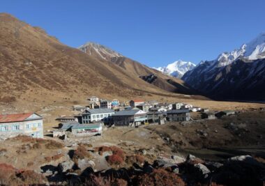
As you round the final ridge, the valley opens completely into a dramatic alpine amphitheater. Kyanjin Gompa sits tucked beneath the towering southwest face of Langtang Lirung. After checking into your lodge by lunchtime, spend your afternoon visiting the village’s historic 13th-century monastery or touring the government-supported Kyanjin Yak Cheese Factory, which produces artisanal cheese from native nak (female yak) milk between May and November.
Day 5: Summit Excursion: Kyanjin Ri or Tserko Ri Peak
-
Trekking Distance: Variable; 5 to 9 kilometers (3 to 5.5 miles) round-trip
-
Hiking Duration: 3 to 4 hours (Kyanjin Ri) or 6 to 8 hours (Tserko Ri)
-
Maximum Elevation: 4,380 meters (Kyanjin Ri) or 4,984 meters (Tserko Ri)
-
Ending Elevation: 3,870 meters (Return to Kyanjin Gompa)
-
Terrain & Route: This dedicated acclimatization day offers two distinct alpine climbing options depending on your physical condition and comfort with steep gradients:
-
Option A (Kyanjin Ri – 4,380m): A steep, dirt-and-rock switchback trail directly behind the village. It provides an excellent introduction to higher altitudes with minimal technical risk, overlooking the tumbling icefalls of the Langtang Lirung glacier.
-
Option B (Tserko Ri – 4,984m): A physically demanding, high-altitude alpine push over loose scree and rocky ridges. The lung-burning ascent requires a pre-dawn start but rewards successful hikers with a staggering, unobstructed 360-degree panorama. The view is dominated by the massive walls of Langtang Lirung (7,245 m), Yala Peak (5,520), Dorje Lakpa (6,966), and the massive pyramid of Mt. Shishapangma (8,027m) towering directly across the northern border in Tibet.
-
Day 6: Valley Descent from Kyanjin Gompa back to Lama Hotel
-
Trekking Distance: ~18.3 kilometers (11.3 miles)
-
Hiking Duration: 5 to 6 hours
-
Net Elevation Loss: -1,400 meters
-
Ending Elevation: 2,470 meters (8,103 feet)
-
Terrain & Route: This day reverses your approach itinerary, condensing two days of uphill walking into a single, extended downward stretch. Because you are heading downhill into oxygen-rich air, progress is exceptionally fast. You will trace the valley floor back through Mundu, past the avalanche debris field, and drop below the subalpine line at Ghora Tabela. The path re-enters the humid oak and rhododendron forests, crossing the familiar suspension bridges before stopping for the night at Lama Hotel.
Safety Note: Continuous downhill trekking over stone steps can place intense stress on your knees and quadriceps. Secure your trekking poles tightly and maintain a deliberate, controlled pace.
Day 7: Lama Hotel to Syabrubesi
-
Trekking Distance: ~11.5 kilometers (7.1 miles)
-
Hiking Duration: 4 to 5 hours
-
Net Elevation Loss: -1,010 meters
-
Ending Elevation: 1,460 meters (4,790 feet)
-
Terrain & Route: The final day on the trail follows the familiar contours of the Langtang Khola canyon floor. For an interesting structural variation, many guides opt for the slightly higher alternative trail that routes through Sherpa Gaun (2,563m) and Khangjim. This alternative path offers unique vantage points looking down into the river gorge and passes through traditional terraced farming villages before dropping sharply down to the main suspension bridges. By mid-afternoon, you will arrive back in Syabrubesi to conclude your foot journey.
Day 8: Return Overland Transit from Syabrubesi to Kathmandu
-
Distance Covered: ~122 kilometers (75 miles)
-
Transit Duration: 7 to 9 hours
-
Ending Elevation: 1,395 meters (4,576 feet)
-
Terrain & Route: After an early breakfast, you re-board your private 4×4 jeep or local public bus for the return journey to the capital. The route retraces the winding mountain roads out of the Rasuwa district, passing back through the Dhunche checkpoint and descending toward the warmer, lower valleys surrounding the Trishuli River. The drive concludes by climbing over the outer rim of the Kathmandu Valley, returning you directly to your hotel in Thamel.
Seasonal Analysis: When to Trek Langtang
Choosing the correct seasonal window directly impacts trail conditions, mountain visibility, and your overall safety. The Himalayan trekking calendar is sharply divided into four distinct phases.
1. Spring (March to May) – Peak Floral Season
-
Temperature Range: Lower elevations (Syabrubesi/Lama Hotel) range from 15C to$22C during the day. Nighttime temperatures at Kyanjin Gompa drop to between -5Cand –3C .
-
Trail Conditions: Clear mornings with occasional afternoon cloud build-up or localized showers. Trails are dry and high passes are typically clear of heavy winter snow by mid-April.
-
Highlights: This season offers exceptional biodiversity. Subtropical and temperate zones between 2,000m and 3,000m erupt with blooming rhododendron forests (Lali Gurans), orchids, and magnolia trees. Wildlife, including the endangered red panda and Himalayan tahr, is highly active.
2. Autumn (September to November) – Optimal Clarity
-
Temperature Range: Mild daytime temperatures hovering around 10C to 18C . Nights become progressively colder as November approaches, dropping to between -10 C and -2C at upper limits.
-
Trail Conditions: Exceptionally stable weather systems. The atmospheric scrubbing from the preceding monsoon rains leaves the air remarkably crisp, providing the highest percentage of crystal-clear, unobstructed mountain views.
-
Highlights: This is the absolute peak trekking window. Trails and teahouses operate at maximum capacity. It coincides with major Nepalese festivals like Dashain and Tihar, adding a vibrant cultural layer to the journey.
3. Winter (December to February) – Solitude and Snow
-
Temperature Range: Daytime temperatures rarely exceed 5C(41F) in the upper valley, while nighttime temperatures routinely plummet below -15C .
-
Trail Conditions: High risk of heavy snowfall, ice accumulation on narrow river paths, and occasional trail closures.
-
Highlights: Ideal for experienced alpine hikers seeking absolute solitude and dramatic, snow-draped landscapes. However, it requires advanced cold-weather gear, microspikes, and a flexible itinerary. Many high-altitude teahouses in Kyanjin Gompa close entirely as locals migrate to lower elevations.
4. Monsoon / Summer (June to August) – High-Risk Off-Season
-
Temperature Range: Warm, humid, and wet. Lower trails are slick, with temperatures staying above 20C .
-
Trail Conditions: High risk of landslides along the vehicular road from Kathmandu to Syabrubesi, particularly around Dhunche. The trails feature dense mud and an abundance of leeches in the forested zones below 3,000m. Clouds frequently obscure the peaks completely.
-
Highlights: The valley transforms into a lush, vibrant green, and alpine meadows are carpeted with wildflowers. Monsoon trekking is strictly recommended only for seasoned hikers focusing on botanical research or those working with experienced local guides who can navigate dynamic landslide zones.
Critical Trekking Logistics
1. Required Permits and Regulations
Navigating the regulatory checkpoints in the Rasuwa district requires specific paperwork. Under current trekking guidelines, independent solo trekking without a licensed guide is heavily restricted or banned across various jurisdictions in Nepal to ensure safety; booking through a registered local agency handles all logistics automatically.
-
Langtang National Park Entry Permit: This is a mandatory conservation permit.
-
Cost: NPR 3,000 per person (approx. USD 25) for foreign nationals; NPR 1,500 for SAARC citizens.
-
Where to Acquire: Available at the Department of National Parks and Wildlife Conservation (Bhrikuti Mandap, Kathmandu) or directly at the park entry checkpoint in Dhunche.
-
Requirements: Photocopy of your passport bio-page and two passport-sized photographs.
-
-
TIMS Card / Local Treker Registration: The Trekkers’ Information Management Systems (TIMS) card or local local government registration acts as a critical safety tracking mechanism. This is monitored closely at checkpoints in Dhunche and the entry point of Syabrubesi.
Pro Tip: Keep both your physical permits and digital backups readily accessible in your daypack. These documents are verified at multiple military and civil checkpoints throughout Langtang National Park.
2. Mountain Teahouse Infrastructure & Dining
The Langtang route is a classic “teahouse trek,” meaning you do not need camping or survival gear. The lodges are family-run operations providing fundamental comforts.
-
Lodging: Rooms typically feature two single foam mattresses over wooden frames. While pillows and thick quilts are standard, a personal 3-to-4-season sleeping bag (rated to $-10^\circ\text{C}$ minimum) is highly recommended for hygiene and crucial insulation during freezing alpine nights. Common dining areas are heated in the evenings by central stoves fueled by wood or dried yak dung.
-
Dietary Management: Menus are standardized by local lodge management committees to regulate pricing. The staple dish is Dal Bhat (steamed rice, lentil soup, spiced vegetable curry, and greens), which features free, unlimited refills—making it the most cost-effective, high-calorie fuel source on the mountain. Other options include Momo (dumplings), Thukpa (Tibetan noodle soup), porridge, and basic pastas. Vegetarian and vegan options are standard, and it is highly advised to avoid meat consumption above Lama Hotel, as all meat must be portered up on foot without refrigeration.
3. Power, Connectivity, and Communications
While the trek offers an escape into nature, cellular and utility grids have improved significantly across the central Himalayas.
-
Mobile Networks: Both Ncell and Nepal Telecom (NTC) offer 4G coverage along the trail. NTC generally maintains a more stable, consistent signal within the deep gorges between Syabrubesi and Langtang Village, though connectivity becomes highly dependent on daily weather conditions once you reach the wide glacial basin of Kyanjin Gompa.
-
Satellite Wi-Fi: Many teahouses offer access to private satellite networks like Everest Link or local long-range Wi-Fi systems. Access is granted via pre-paid cards or a flat daily usage fee ranging from USD 3 to USD 5. Expect speeds to slow down significantly during peak evening hours when everyone logs on.
-
Auxiliary Fees: Power is a premium asset in the mountains, often relies on solar panels, and is not included in the baseline room rate. Teahouses charge incremental fees for the following services:
-
Device Charging: USD 2 to USD 4 per hour (carrying a high-capacity $20,000\text{mAh}$ power bank is essential).
-
Hot Gas/Solar Showers: USD 2 to USD 5 per shower (showering is not recommended above Langtang Village to avoid rapid cooling and hypothermia risks).
-
Conclusion: Synthesizing the Langtang Experience
Ultimately, the Langtang Valley Trek defies the hyper-commercialized, peak-bagging culture often found on more crowded Himalayan circuits. Rather than focusing purely on technical endurance or reaching a grueling physical checkpoint, Langtang is fundamentally a trek of connection—one that offers an intimate window into the resilience of central Nepal’s mountain communities and the changing dynamics of its unique alpine ecosystems.
It strikes a precise structural balance for a trekker: challenging enough to require physical preparation and cardiovascular stamina, yet accessible enough to prevent exhaustion from overshadowing the landscape.
To optimize your journey through the Valley of Glaciers, keep these final actionable directives in mind:
1. Master the Art of Minimalist Packing
Because there are no domestic flight weight restrictions on this route, it can be tempting to overpack. However, keeping your baseline pack weight between 8 and 9 kilograms (17 to 20 pounds) is critical for your comfort—or the physical well-being of your porter. Prioritize a technical layering system: a breathable base layer, a heavy insulating mid-layer (down jacket), and a wind- and waterproof outer shell.
2. Commit to Sustainable Travel and Ethical Guiding
Hiring a licensed local guide does more than just secure your safety through dynamic terrain and landslide zones. It provides critical economic support directly to Tamang families who rely on tourism to sustain their communities. Furthermore, traveling with a local guide grants you deep access to oral histories, regional customs, and hidden monastic traditions that you won’t find in any standard guidebook.
3. Embrace the Philosophy of Bistarai, Bistarai
The golden rule of high-altitude trekking in Nepal is captured in the Nepali phrase Bistarai, bistarai—meaning “slowly, slowly.” Forcing a rapid pace up the steep river canyons between Syabrubesi and Lama Hotel only increases your risk of early fatigue and poor acclimatization. By deliberately managing your heart rate, staying consistently hydrated with 3 to 4 liters of filtered water daily, and matching your stride to the natural rhythm of the mountain, you allow your body to adapt smoothly to the thinning air.
The Langtang Valley remains a rare sanctuary where the grandeur of the high Himalayas meets a deeply grounding cultural journey. By stepping onto the trail with preparation, respect, and curiosity, you ensure that your journey through this magnificent glacial valley is both personally unforgettable and profoundly impactful to the resilient communities hosting you.