The Ultimate Guide to the Langtang Gosaikunda Trek: Mountains, Monasteries, and Sacred Lakes
If you are searching for a Himalayan adventure that seamlessly weaves together dramatic mountain landscapes, vibrant indigenous culture, and profound spiritual heritage—all while bypassing the dense crowds of the Everest or Annapurna circuits—the Langtang Gosaikunda Trek stands out as Nepal’s premier choice.
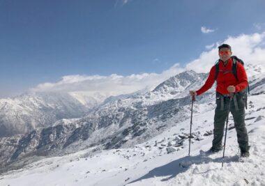
Perfectly situated just north of Kathmandu in the rugged Rasuwa district, this trail charts a course through the country’s historic first Himalayan national park. It takes trekkers from deep, glacial valley floor views up to high-altitude mountain passes, culminating at a striking cluster of alpine lakes revered for centuries.
Why Choose the Langtang Gosaikunda Trek?
1. A Masterful Conjoining of Two Diverse Landscapes
The brilliance of this route lies in how effortlessly it bridges two entirely different ecological and spiritual worlds. The first half of the journey immerses you in the classic glacial topography of the Langtang Valley, leading to the high-mountain pastures of Kyanjin Gompa. The second half shifts dramatically into the stark, subalpine lake-strewn plateaus and exposed ridges of the sacred Gosaikunda region.
2. Living History: The Tamang Heritage
The trails serve as a living museum for the ancestral traditions of the Tamang community. As an indigenous group with Tibetan-influenced roots, their distinct craftsmanship, language, and traditional attire define the region. Your daily trek is framed by cultural touchstones:
-
Mani Walls & Chortens: Hand-carved stone tablets inscribed with Buddhist mantras (Om Mani Padme Hum) line the trails.
-
Prayer Wheels: Copper cylinders spun by trekkers and locals alike to release blessings into the mountain wind.
-
Architecture: The classic, wood-accented alpine teahouses offer a firsthand look at native mountain masonry and hospitality.
3. A Fragile, Biodiverse Sanctuary
Spanning 1,710 square kilometers since its establishment in 1976, Langtang National Park protects a multi-tiered ecosystem that shifts rapidly with altitude:
-
The Flora: The trail begins in humid subtropical forests dominated by Sal and Chir Pine, quickly climbing into temperate bands of oak, maple, and laurel. Above 3,000 meters, these give way to subalpine stands of Silver Fir and massive rhododendron orchards that paint entire hillsides in crimson, pink, and white during the spring.
-
The Fauna: This park remains a globally critical habitat for over 46 mammal species, most notably the highly endangered, arboreal Red Panda. Trekkers sharing the valley with locals may also cross paths with Himalayan black bears, musk deer, gray langurs, and the elusive snow leopard roaming the high crags.
-
Avian & Winged Life: For bird enthusiasts, the park is a paradise hosting 250+ bird species. The canopy frequently reveals the iridescent plumage of the Danphe (Himalayan Monal—Nepal’s national bird), blood pheasants, and majestic Himalayan griffons catching thermal updrafts. Over 70 species of high-altitude butterflies add vibrant movement to the alpine meadows.
4. Front-Row Seats to Giant Peaks
Unlike treks where big mountains remain distant backdrops, the Langtang circuit puts you in immediate, humbling proximity to the ice-carved topography of the Central Himalayas:
-
Langtang Lirung (7,234m): The undiscovered monarch of the valley, dominating the northern skyline with massive icefalls.
-
Dorje Lakpa (6,966m): An elegant, razor-sharp pyramid peak that serves as a visual anchor for the region.
-
Ganesh Himal & Yala Peak: Accessible, jagged massifs that frame the high-altitude horizon.
-
Naya Kanga: A challenging trekking peak that guards the pass into Helambu, overlooking the northern borders of Tibet’s vast Qomolangma National Nature Preserve.
Key Trekking Metrics at a Glance
Before setting foot on the trail, understanding the foundational logistics ensures a well-planned expedition. Here is the core operational data for the journey:
| Metric | Core Specifications & Data |
| Total Duration | 9 to 14 days (A 12–13 day itinerary is highly advised to ensure safe, gradual altitude adjustment) |
| Trail Difficulty | Moderately Strenuous (Demands robust physical stamina, though it requires no technical mountaineering skills or climbing gear) |
| Maximum Altitude | 4,610 meters at the crest of the Lauribina La Pass, reaching up to ~4,984 meters if scaling the Tsergo Ri viewpoint |
| Trailhead Location | Syabrubesi (1,503m) — Accessed via a rugged 7-to-8-hour overland journey (122 km) heading north from Kathmandu |
| Lodging Style | Traditional, locally operated alpine Teahouses (offering basic twin-sharing rooms, communal dining, and local meals) |
| Mandatory Entry Permits | Langtang National Park Entry Permit coupled with an authorized TIMS (Trekkers Information Management System) Card |
The Sacred Significance & Lore of Gosaikunda Lake
Perched high in the alpine zone at 4,380 meters, Gosaikunda is far more than a stunning geographical landmark. It anchors an intricate, fragile alpine wetland system composed of 108 interconnected glacial lakes—including neighboring Bhairavkunda and Saraswatikunda—collectively recognized as a protected global Ramsar Site. For centuries, this high-altitude basin has held immense spiritual and historical weight.
1. The Hindu Legend of Nilkantha Shiva
According to ancient Vedic mythology, the creation of Gosaikunda is tied directly to the Samudra Manthan (the churning of the cosmic ocean). During this cosmic event, a lethal, dark poison (Halahala) emerged, threatening to consume all of creation. To protect the universe, Lord Shiva drank the venom. The poison held such intense potency that it locked in his throat, turning it a deep blue and earning him the moniker Nilkantha.
In agonizing pain from the burning venom, Shiva sought the cold sanctuary of the Himalayas. He struck his divine trident (Trishul) deep into the mountain ridge. Holy water immediately burst forth from the rock, cooling his torment and collecting into the basin that is known today as Gosaikunda.
2. The Janai Purnima Pilgrimage & Shamanic Rituals
Every August, during the auspicious full moon festival of Janai Purnima, the quiet alpine trails transform. Thousands of devout Hindu pilgrims from across Nepal and India undertake a grueling journey to the lake.
They plunge into the near-freezing holy waters, a ritual believed to wash away lifetimes of sins. A central highlight of this event is the presence of traditional faith healers and shamans (Jhankris), who trek to the lake in elaborate costumes, beating traditional drums and chanting ancient incantations to renew their spiritual powers.
3. Tibetan Buddhism & The Holy Kora
For the indigenous Tamang people and Tibetan Buddhists, the lake holds equal spiritual gravity. They believe the sacred waters are spiritually tied to Guru Rinpoche (Padmasambhava), the legendary master who brought Buddhism to Tibet. Buddhist pilgrims journey here to pray for the souls of the deceased and perform a Kora—a meditative, clockwise circuit walk around the massive perimeter of the lake.
4. Historical Legacy: The Retreat of a Warrior
Gosaikunda also claims a unique place in the geopolitical history of Nepal. Bada Kaji Amar Singh Thapa, one of Nepal’s greatest military commanders who led forces on the western front during the Anglo-Nepalese War (1814–1816), sought absolute peace late in life. Refusing to live under British-influenced political shifts, the legendary general retired to these isolated, sacred mountains, spending his final days meditating in a cave near the shores of Gosaikunda.
Best Time to Plan Your Journey
Timing your trek dictates your visibility, temperature comfort, and overall safety on the high passes. The trekking year is defined by three distinct alpine seasons:
Autumn (September to November) • The Peak Window: This post-monsoon period offers the most reliable weather of the year. The heavy summer rains wash the atmosphere completely clean
, resulting in crisp air, comfortable daytime hiking temperatures, and unparalleled, blue-sky visibility of the high ridges and peaks.
Spring (March to May) • The Blooming Wilderness: As temperatures rise, the lower and middle elevations come alive. This is the ultimate season for nature lovers, as the vast subalpine forests burst into a sea of red, pink, and white rhododendron blooms. Days are longer and wildlife activity peaks, though afternoon clouds are more common than in autumn.
Winter (December to February) • The Icy Challenge: For trekkers seeking complete solitude, winter offers empty trails and a starkly beautiful, snow-covered landscape. The surface of Gosaikunda freezes completely into solid ice. However, daytime temperatures drop significantly and nights are bitterly cold (often plunging below -15°C at high altitudes), requiring heavyweight cold-weather gear and traction devices like microspikes for safe pass crossings.
Route Overview & A Comprehensive Day-by-Day Itinerary
While the trek can be condensed into a grueling 9 days or stretched out to 14 days, a 12-to-13-day itinerary strikes the perfect balance. It builds in necessary physiological safety margins for altitude acclimatization while ensuring you don’t rush through the striking cultural milestones.
Phase 1: Deep into the Langtang Valley
-
Day 1: Kathmandu to Syabrubesi (1,503m) * Distance/Time: ~122 km, 7–8 hours overland drive via public bus or private 4WD.
-
Terrain & Highlights: The drive skirts along the edge of deep river gorges, passing through the bustling trading town of Trishuli Bazaar before climbing sharply via hairpin bends into the Rasuwa district.
-
-
Day 2: Syabrubesi to Lama Hotel (2,470m) * Distance/Time: ~11 km, 5–6 hours trek; Altitude Gain: +967m.
-
Terrain & Highlights: Crossing the suspension bridge over the Bhote Koshi River, you immediately enter a dense wilderness of oak, maple, and bamboo. The trail follows the roaring Langtang Khola upstream, utilizing steep stone steps. Keep an eye out for wild honeybee hives hanging from sheer cliff faces.
-
-
Day 3: Lama Hotel to Langtang Village (3,430m) * Distance/Time: ~14 km, 5–6 hours trek; Altitude Gain: +960m.
-
Terrain & Highlights: You pass through Ghora Tabela (2,970m), a former Tibetan resettlement project where the valley suddenly cracks open. The dense jungle transitions into alpine meadows dotted with prayer flags. You will cross the sobering memorial site of old Langtang Village, which was entirely buried by a massive co-seismic ice-and-rock avalanche during the 2015 earthquake, before arriving at the rebuilt settlement nearby.
-
Phase 2: Spiritual Hubs & Glacial Peaks
-
Day 4: Langtang Village to Kyanjin Gompa (3,830m) * Distance/Time: ~6 km, 3–4 hours trek; Altitude Gain: +400m.
-
Terrain & Highlights: A shorter, gentle climb past massive mani walls (always pass them on the left/clockwise) and wooden bridges over glacial streams. Kyanjin Gompa sits in a spectacular natural amphitheater flanked by icefalls. Take the afternoon to sample fresh yak cheese at the government-established factory or visit the ancient monastery itself.
-
-
Day 5: Acclimatization & Peak Exploration Day * Distance/Time: Variable, 5–7 hours round trip.
-
Options: * Kyanjin Ri (4,773m): A steep, non-technical ridge walk directly behind the village offering views of the Langtang icefall.
-
Tsergo Ri (4,984m): A highly demanding, high-altitude push over loose scree and rocky blocks. Reaching the prayer-flag-strewn summit grants a mesmerizing 360-degree look at Langtang Lirung, Yala Peak, and the vast glacial expanses stretching toward Tibet.
-
-
Phase 3: The Sacred Lakes of Gosaikunda
-
Day 6: Kyanjin Gompa to Lama Hotel (2,470m) * Distance/Time: ~20 km, 5–6 hours; Altitude Loss: -1,360m.
-
Terrain & Highlights: Retracing your steps down the valley. Gravity is on your side, making this a fast, long descent back into the oxygen-rich forested zone.
-
-
Day 7: Lama Hotel to Thulo Syabru (2,230m) * Distance/Time: ~11 km, 5 hours; Altitude Loss/Gain: A net descent followed by a sharp climb.
-
Terrain & Highlights: The trail drops down to Bamboo by the river, then splits off from the main Langtang route. You cross a bridge and begin a steep, hot climb up to Thulo Syabru, a magnificent Tamang village terraced across a massive hillside ridge.
-
-
Day 8: Thulo Syabru to Shin Gompa / Chandanbari (3,330m) * Distance/Time: ~7 km, 4–5 hours; Altitude Gain: +1,100m.
-
Terrain & Highlights: A steady, punishing incline through pristine hemlock and rhododendron forests. You will pass through Dursagang before reaching the serene ridge settlement of Shin Gompa. This village features a legendary local dairy that produces authentic, artisanal yak cheese and a beautiful, quiet Buddhist monastery.
-
-
Day 9: Shin Gompa to Gosaikunda Lake (4,380m) * Distance/Time: ~9 km, 5–6 hours; Altitude Gain: +1,050m.
-
Terrain & Highlights: The trail climbs dramatically out of the tree line past Lauribina (3,910m)—a spectacular ridge point showcasing views of the Annapurnas, Manaslu, and Ganesh Himal. Entering the high alpine zone, you skirt a cliffside path to witness the first of the sacred lakes, Saraswatikunda, followed by Bhairavkunda, before arriving at the shores of the great Gosaikunda.
-
-
Day 10: Gosaikunda Lake over Lauribina La Pass (4,610m) to Ghopte (3,440m) * Distance/Time: ~12 km, 6–7 hours; Altitude Gain/Loss: +230m to the pass, then a steep -1,170m descent.
-
Terrain & Highlights: You climb along the edge of the lake before ascending a rugged, exposed trail to the rocky crest of Lauribina La Pass. Marked by stone cairns and hundreds of fluttering prayer flags, this is the highest point of the trek. The descent on the other side is steep and rocky, leading down into the Helambu region.
-
-
Day 11 & 12: Ghopte to Kutumsang, Chisapani, and Kathmandu * Terrain & Highlights: The trail rolls through high ridges, lush oak forests, and typical hillside Brahmin and Chhetri villages, eventually ending near the rim of the Kathmandu Valley for your drive back to the capital.
Detailed Climate & Seasonal Matrix
Trek Difficulty, Logistics, and Preparation
Understanding Acute Mountain Sickness (AMS)
Because this itinerary takes you from 1,503 meters to nearly 5,000 meters in a matter of days, understanding high-altitude physiology is crucial.
-
The Golden Rule: Never ascend more than 400–500 meters of sleeping altitude per 24-hour period once above 3,000 meters.
-
Prevention: Drink 4 to 5 liters of water daily. Hydration helps oxygenate your blood. Avoid alcohol and tobacco entirely on the way up. Consider carrying Acetazolamide (Diamox) after consulting a doctor.
Regulatory Compliance & Mandatory Permits
Independent, unguided trekking is heavily restricted in Nepal’s national parks to ensure safety. You must secure two permits, which can be acquired at the Department of Tourism in Kathmandu or directly at the park checkpoints:
-
TIMS Card (Trekkers Information Management System): NPR 2,000 (~$15 USD). It is mandatory to hire a licensed guide to activate this.
-
Langtang National Park Entry Permit: NPR 3,000 (~$23 USD) plus 13% VAT for foreign nationals; SAARC citizens receive a discounted rate of NPR 1,500.
Master Packing Essentials
To seamlessly transition from the hot, humid sub-tropical river valleys to freezing high-mountain passes, pack according to a strict multi-layer system:
-
The Base Layer: High-quality moisture-wicking merino wool or synthetic thermal tops and bottoms (avoid cotton, which retains sweat and freezes).
-
The Insulation Layer: A breathable mid-weight fleece jacket and durable trekking trousers.
-
The Outer Shell: A windproof, waterproof jacket (Gore-Tex or equivalent) and a high-loft down jacket rated for at least -15°C.
-
Footwear: Broken-in, high-ankle trekking boots, multiple pairs of merino wool hiking socks, and a pair of lightweight camp shoes/sandals for the evenings.
-
Gear & Safety: A 50L–60L rucksack with a rain cover, a -10°C rated sleeping bag (teahouse blankets are often insufficient in late autumn/winter), collapsible trekking poles to save your knees on descents, a 100+ lumen headlamp with spare batteries, UV-blocking sunglasses, and water purification tablets or a filtration pump.