The Last Frontier: An In-Depth Guide to Trekking in Nepal’s Distant Dolpo Region
For seasoned adventurers who have already crossed the Thorong La or stood at Everest Base Camp, the well-trodden trails of the Annapurna and Khumbu regions can sometimes feel a bit too familiar. If you are seeking a profound return to raw, untouched wilderness, Nepal still guards an untamed frontier. Located in the remote mid-western reaches of the country and bordered by the Tibetan Plateau to the north, lies the mystical, restricted region of Dolpo.
Dolpo is not a standard trekking destination. It is a vast, high-altitude desert oasis defined by deep-blue turquoise lakes, ancient Bon monasteries, and grueling mountain passes. Immortalized by Peter Matthiessen’s 1978 National Book Award-winning travelogue The Snow Leopard and Eric Valli’s 1999 Oscar-nominated film Himalaya, Dolpo offers a rare, living window into a centuries-old Tibetan lifestyle that remains thoroughly insulated from modern globalization.
If you are looking for a true wilderness expedition, this guide outlines everything you need to know about navigating the geography, culture, and logistics of the Dolpo region.
Geographic and Cultural Landscape: What Makes Dolpo Unique?
Unlike the teahouse-centric infrastructures of eastern and central Nepal, trekking in Dolpo demands a fully self-sufficient expedition mentality. The region is physically and culturally distinct from the rest of the country due to several key factors:
1. The Trans-Himalayan Rain-Shadow Advantage
Dolpo sits directly behind the massive Dhaulagiri massif (8,167m), which acts as a colossal meteorological barrier. This unique positioning places Dolpo in a trans-Himalayan rain shadow. Consequently, while the rest of mainland Nepal is heavily drenched by south Asian monsoon rains from June to August, Dolpo remains dry, arid, and highly trekable. This makes it one of the premier summer trekking destinations in Asia, offering barren, canyon-like landscapes reminiscent of Tibet.
2. The Living Sanctuary of Pre-Buddhist Bon-Po Culture
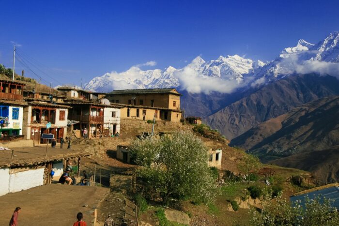
Culturally, Dolpo is a living museum. It is one of the last remaining enclaves on Earth where the ancient Bon-Po religion—a shamanistic, animistic faith that predated Buddhism in Tibet—is actively practiced alongside Tibetan Buddhism. As you walk through villages, you will notice Bon monasteries (Gompas) where trekkers must circumambulate shrines counter-clockwise, rather than the clockwise direction practiced by traditional Buddhists.
3. Uncompromised Wilderness Ecosystems
There are no luxury lodges, heated dining halls, or stable cellular networks here. Trekking through Dolpo requires a classic wilderness setup: camping in high-altitude meadows under pristine skies, relying on mule trains for logistics, and traversing the Shey Phoksundo National Park—Nepal’s largest national park. The park serves as a critical habitat for endangered wildlife, including the Himalayan blue sheep (bharal) and the elusive snow leopard.
Understanding the Routes: Lower vs. Upper Dolpo
The region is administratively and geographically split into two distinct sectors. Choosing between them depends on your budget, timeframe, and physical conditioning.
-
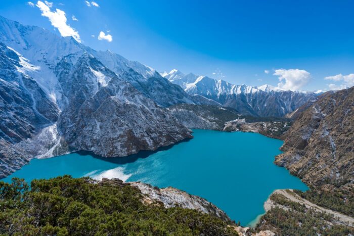
The Lower Dolpo Circuit (Approx. 14–18 Days): This route serves as a magnificent introduction to the region’s biodiversity. It transitions from lush pine, bamboo, and cedar forests into stark alpine environments. The crown jewel of this trek is Phoksundo Lake, a mesmerizing alpine lake sitting at 3,611 meters, famed for its deep, shifting turquoise hues and the fact that it is completely devoid of aquatic life. This loop requires crossing two challenging high passes: Numa La (5,309m) and Baga La (5,169m), before dropping into the unique, flat-roofed mudbrick village of Dho Tarap—one of the highest permanent human settlements on earth.
-
The Upper Dolpo Circuit (Approx. 24–28 Days): For those seeking an epic, once-in-a-lifetime Himalayan odyssey, Upper Dolpo crosses far north into the restricted inner valleys near the Tibetan border. This demanding route takes you beyond Phoksundo Lake and across the grueling Kang La Pass (5,360m) to reach Shey Gompa, a 12th-century monastery nestled at the base of the sacred Crystal Mountain (a peak embedded with marine fossils, circumambulated by hundreds of pilgrims annually).
Essential Logistics and Permit Framework
Because Dolpo shares a sensitive border with Tibet and hosts highly fragile cultural ecosystems, independent trekking is strictly forbidden. You must book through a registered Nepalese trekking agency, hire a licensed guide, and travel with a minimum of two people in your group to secure government permits.
-
Permit Costs: * Lower Dolpo: Requires a restricted area permit costing $20 USD per person, per week.
-
Upper Dolpo: Requires a highly exclusive Department of Immigration permit costing $500 USD per person for the first 10 days, and $50 USD per day for every day thereafter.
-
Additionally, a Shey Phoksundo National Park entry permit (approx. $30 USD) is mandatory for both regions.
-
-
Getting There: The journey is a multi-step transit. Trekkers typically fly from Kathmandu to the sub-tropical lowland city of Nepalgunj. The following morning, a thrilling mountain flight brings you into the short, gravel airstrip of Juphal (2,475m) in western Nepal, which serves as the official trailhead. Because these mountain flights are entirely weather-dependent, building 2 to 3 buffer days into your travel itinerary is strongly advised.
Thoughts
A trek into Dolpo is far more than a physical endurance test; it is an active step back in time. It demands mental resilience, a willingness to disconnect entirely from modern conveniences, and a deep respect for an isolated culture. For the select few willing to make the journey, the reward is an unparalleled sense of solitude, dramatic trans-Himalayan vistas, and a rare look at a frontier that remains largely hidden from the rest of the world.
Strategic Route Selection: Lower Dolpo vs. Upper Dolpo
The Dolpo region is geographically and administratively bifurcated into two primary trekking circuits. Choosing between them dictates not only the duration and physical demands of your expedition, but also the specific ecological zones and cultural depths you will experience.
1. The Lower Dolpo Circuit (14–18 Days)
Overview & Terrain Dynamics Lower Dolpo serves as an excellent introduction to the region’s geographical diversity. This circuit cuts through the lower valleys of the Shey Phoksundo National Park, acting as a transitional corridor. Trekkers experience a dramatic ecological shift: starting in lush subtropical forests of pine, oak, and giant cedar, the trail climbs alongside the raging waters of the Bheri and Phoksundo rivers before breaking through the tree line into stark, arid trans-Himalayan landscapes.
Key Technical & Cultural Highlights:
-
Phoksundo Lake (3,611m): The undisputed centerpiece of the trek. This alpine, oligotrophic lake is famous for its striking turquoise color—a result of its extreme depth (reaching up to 145 meters) and the lack of organic matter or aquatic life. On its southern cliffs sits Ringmo Village, a traditional settlement where you can observe centuries-old Bon-Po practices.
-
The High Mountain Passes: The trek features two grueling, consecutive high-altitude passes:
-
Baga La (5,169m): Known for its steep, rocky switchbacks that offer panoramic views of the Kanjirowa Himalayan range.
-
Numa La (5,309m): A demanding, windswept saddle that provides sweeping views of Dhaulagiri ($8,167\text{m}$) to the south and the barren Tibetan peaks to the north.
-
-
Dho Tarap (4,080m): After crossing the passes, you descend into this remarkable valley. Composed of several clustered mudbrick villages, Dho Tarap is recognized as one of the highest permanently inhabited human settlements on Earth. It serves as a vital trade junction where local Dolpo-pa combine agro-pastoral farming (mostly barley and buckwheat) with trans-Himalayan yak caravans.
2. The Upper Dolpo Circuit (24–28 Days)
Overview & Terrain Dynamics For elite trekkers seeking a true world-class wilderness expedition, Upper Dolpo extends far north into the restricted inner valleys adjacent to the Tibetan border. This route requires exceptional physical conditioning and mental resilience, as it spends weeks entirely cut off from modern infrastructure. The landscape here is an extension of the Tibetan Plateau—a high-altitude desert characterized by wind-eroded canyons, massive scree slopes, and extreme exposure to the elements.
Key Technical & Cultural Highlights:
-
The Kang La Pass (5,360m): To enter the inner sanctuary of Upper Dolpo from Phoksundo Lake, trekkers must scale this formidable pass. The ascent involves navigating steep, unstable scree fields, but the summit rewards climbers with a stark, birds-eye view of the forbidden landscapes stretching toward Tibet.
-
The Sacred Shrine of Shey Gompa (4,160m): Nestled on the other side of Kang La, this legendary 12th-century monastery belongs to the Kagyupa sect of Tibetan Buddhism. It is the spiritual heart of Dolpo.
-
The Crystal Mountain (Shel-ri): Shey Gompa sits at the base of this mystical peak. The mountain gets its name from its unique geological composition—its cliffs are heavily laced with veins of quartz and marine fossils, proving the region was once an ancient ocean floor (the Tethys Sea). Every year during the full moon of late summer, pilgrims travel here to complete a holy kora (circumambulation) around the mountain.
-
The Isolated Northern Villages (Saldang and Yangjer Gompa): The return loop winds through Saldang (3,620m), the largest village cluster in Upper Dolpo. This arid valley remains highly dependent on the traditional salt trade. Local traders navigate caravan routes over high passes to trade Tibetan rock salt for grain from the middle hills of Nepal, maintaining a barter economy that has vanished virtually everywhere else in the world.
Summary Comparison
| Factor | Lower Dolpo Circuit | Upper Dolpo Circuit |
| Average Duration | 14 to 18 Days | 24 to 28 Days |
| Max Elevation | $5,309 (Numa La) | $5,360 (Kang La) |
| Permit Cost | $20 USD / week | $500 USD for first 10 days (+ $50/day after) |
| Terrain Style | Forested gorges to alpine valleys | High-altitude trans-Himalayan desert |
| Primary Culture | Mixed Bon-Po and Tibetan Buddhist | Deeply isolated Tibetan Buddhist & Nomad |
| Physical Difficulty | Strenuous | Extreme / Expedition Level |
Expedition Logistics & Operational Realities: What to Expect
Trekking in the Dolpo region requires shifting your mindset from the modern, commercialized tea-house trekking found in Everest or Annapurna to that of a full-scale, self-sufficient wilderness expedition.
Accommodations & Field Logistics
Because infrastructure in this remote corner of western Nepal is minimal, your daily life on the trail relies heavily on a synchronized support crew.
-
The Expedition Framework: While a handful of rudimentary local homestays have emerged in Ringmo (near Phoksundo Lake) and Dho Tarap, they lack standard amenities like hot showers, indoor plumbing, or electricity. Therefore, the vast majority of both Lower and Upper Dolpo itineraries are operated as fully supported camping treks.
-
Crew Architecture: Your expedition team will typically outnumber the trekkers. A registered agency coordinates a licensed mountain guide, a camp chef, kitchen assistants, and local muleteers.
-
Daily Operations: A train of pack mules or yaks transports your heavy duffel bags, mess tents, sleeping tents, kitchen equipment, and fresh food supplies for the entire duration. While you hike with a light daypack, the crew ahead moves swiftly to pitch camp and prepare fresh, three-course hot meals daily, prioritizing high-carbohydrate and nutrient-dense foods to fuel high-altitude exertion.
-
Power & Connectivity: Cellular service is virtually non-existent past Juphal. Satellite phones or Garmin inReach devices are mandatory for emergency communication. For power, you must rely entirely on personal, portable solar panels to charge camera batteries and devices, as there is no grid electricity.
Aviation Transit & Geographic Access
Reaching the remote trailhead of Dolpo is an multi-stage aviation challenge where itineraries must remain flexible.
-
Flight 1: Kathmandu (KTM) to Nepalgunj (KEP): You begin with a standard domestic flight from Kathmandu down to the sub-tropical plains of the Terai region along the Indian border. Trekkers typically overnight in Nepalgunj.
-
Flight 2: Nepalgunj (KEP) to Juphal (VNJ): Early the following morning, you board a small, twin-otter turboprop plane for a dramatic, 35-minute mountain flight. This flight maneuvers through deep river gorges and ascends into the mountains, landing on a short, bench-like mountain airstrip at Juphal (2,475m).
Critical Advisory: The flight from Nepalgunj to Juphal operates strictly under visual flight rules (VFR). High winds, mountain fog, or cloud cover in the passes can instantly ground flights for days at a time. It is vital to build at least 2 to 3 contingency buffer days into your international travel itinerary to account for potential weather delays.
Regulatory Permits & Legal Compliance
Due to Dolpo’s proximity to the sensitive international border with Tibet and its fragile cultural heritage, the Department of Immigration strictly regulates access. Independent trekking (FIT) is completely illegal. To obtain the necessary permits, you must go through an authorized Nepalese trekking agency, travel with a minimum of two trekkers, and be accompanied by a licensed guide.
The permit system is strictly tiered based on your route:
-
Shey Phoksundo National Park Entry Fee: Mandatory for all visitors at approximately $30 USD (RS 3,000) per person.
-
Lower Dolpo Restricted Area Permit: Costs $20 USD per person, per week.
-
Upper Dolpo Special Restricted Area Permit: This is one of the most exclusive and expensive permits in Nepal. It costs $500 USD per person for the first 10 days, plus an additional $50 USD per person for every day thereafter.
Seasonal Climate Analysis: When to Go
Dolpo’s unique geography creates a climate profile that differs drastically from the rest of mainland Nepal, making it an excellent alternative during months when other trails are inaccessible.
-
Spring (April to May): A transitional window. Temperatures in the valleys range from 10°C to 20°C during the day, though nights drop below freezing above 4,000 meters. The lower valleys burst into color with blooming rhododendrons and alpine wildflowers. However, early spring trekkers may still encounter heavy winter snow blocking the high passes like Numa La or Kang La.
-
Summer / Monsoon (June to August): While the rest of Nepal experiences heavy downpours, muddy trails, and obscured mountain views, this is prime trekking season for Dolpo. Safe behind the Dhaulagiri rain shadow, Dolpo enjoys clear, dry weather. This season coinciding with peak agricultural activity—local communities are out farming barley fields and herding livestock, making it the most vibrant cultural window.
-
Autumn (September to November): The most stable weather window for high-altitude pass crossings. The post-monsoon air is incredibly crisp, offering unparalleled visibility of the Dhaulagiri and Kanjirowa massifs. Daytime temperatures are highly comfortable for hiking, though night temperatures above 4,000 meters plunge significantly down to -10°C or -15°C.
Final Thoughts
Embarking on a journey through the Dolpo region is not merely a strenuous physical challenge; it is an immersive exercise in time travel. It demands physical endurance, mental resilience to handle isolation, and deep cultural humility. For the select few travelers willing to navigate the strict permits, unpredictable flights, and rigorous camping conditions, the payoff is unparalleled: absolute solitude on the trail, intact ancient traditions, and a rare look at a Himalayan frontier that remains fiercely independent of the modern world.