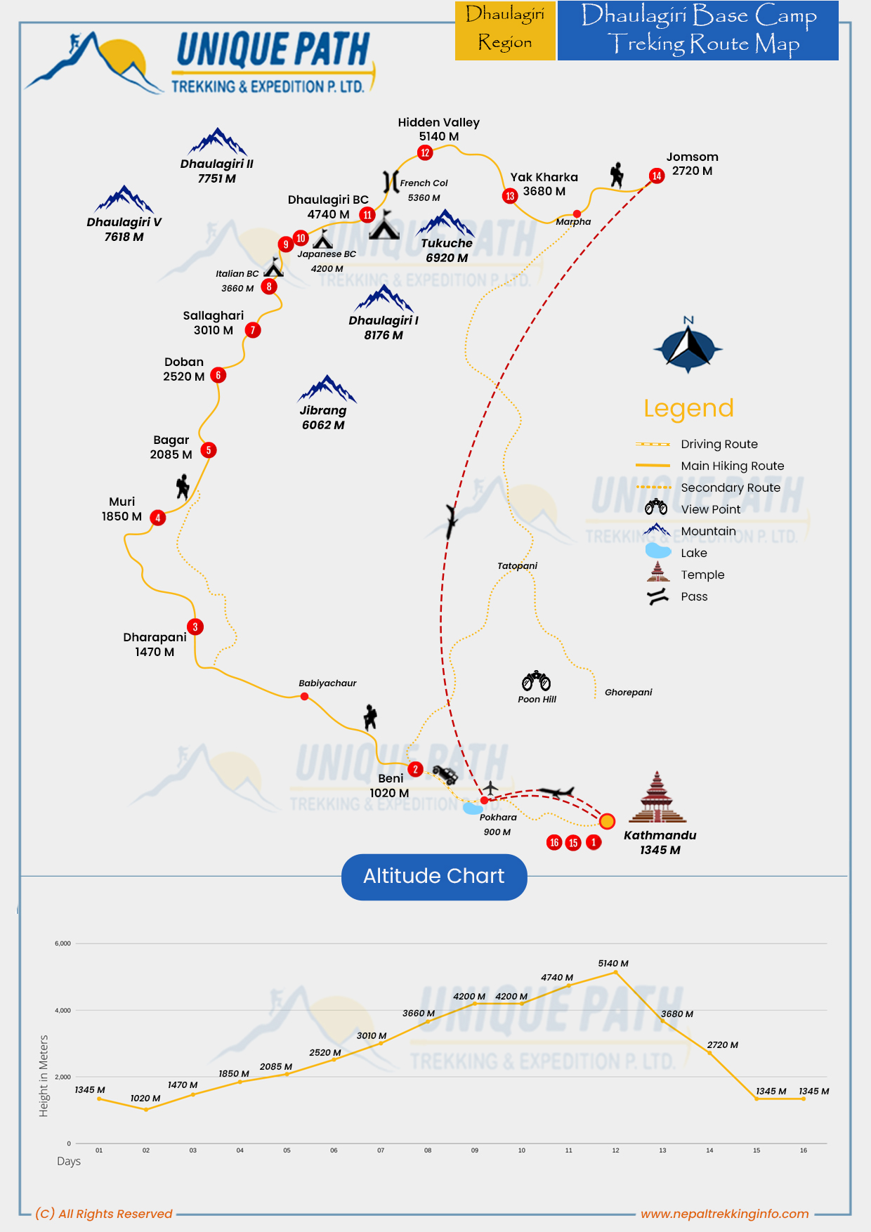
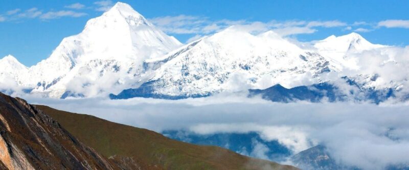
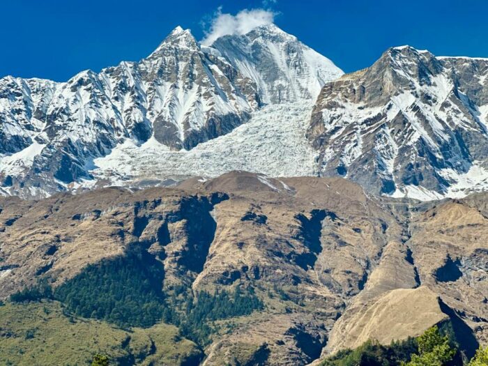
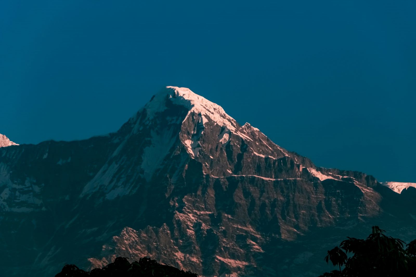
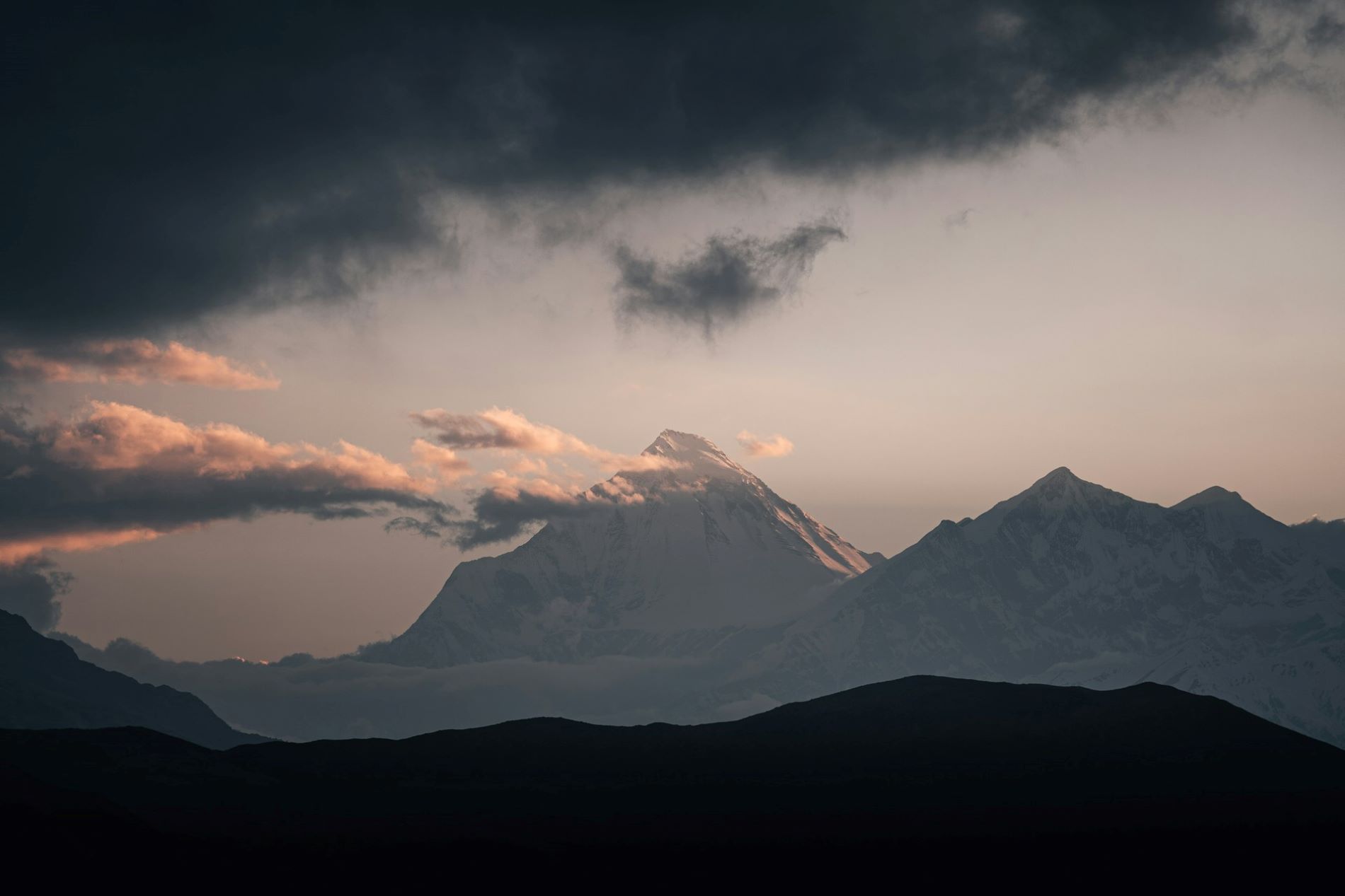
Dhaulagiri Trek
Adventure Trek

Dhaulagiri Trek

Book Now

Other Packages

Trip Facts

  • Max Altitude Upto 5360m
  • Duration 16 Days
  • Group Size 2 - 15

Overview

Dhaulagiri Trekking provides massive mountains range of Dhaulagiri consisting of fifteen 7000 meter peaks is magnificent. Trekking of the main paths is not only possible, but can be immensely rewarding. Though you do need a sense of adventure and an increased ability to deal with unexpected. Geographically, it is a land of dramatic contrast. Trekking around the giant Himalayan Peak Dhaulagiri (8th highest Himalayan Peaks of the world) is one of the most challenging treks.

Similarly, the trek goes through big challenging mountain passes, crossing over French pass (5360 meter) and Thapa Pass (5200 meter); It is a challenging walk on an icy track. The massive mountains range of Dhaulagiri consisting of fifteen 7000 meter peaks is magnificent. Trekking of the main paths is not only possible, but can be immensely rewarding, though you do need a sense of adventure and an increased ability to deal with unexpected. Geographically, it is a land of dramatic contrast.

Trekking in this region means an exploration of the wild. Recently reopened this thrilling region shows its long kept secrets, like the Gandaki Gorge, the deepest Gorge in the world !! Dhaulagiri means “white mountain” though many mountains over the world have names which translate to white mountain, this is without doubt the most astonishing one.

Itinerary

Day 01

Arrival in Kathmandu airport. Our Airport Representative transferred to hotel by private tourist vehicle.

Our Airport Representative transferred to hotel by private tourist vehicle.

  • Max. Altitude
    1345m/4412ft
  • Accomodation
    3 stars level hotel
Day 02

After breakfast transfer domestic airport and flight to Pokhara then drive to Beni by car. Flight 30 minutes then drive by car 4 hours.

After a leisurely breakfast, you will drive to the airport, where you will then fly to Pokhara
before driving to Beni (approx. 3 hours). We will be staying overnight at Beni.

  • Max. Altitude
    1020m/3345ft
  • Meal
    Breakfast/ Lunch/Dinner
  • Accomodation
    Hotel/Tea house
Day 03

Beni to Dharapani. Walking 6 hours.

You will traverse several Gurung and Chhetri villages as you stroll along the Myagdi Khola today, as well as a few suspension bridges. Additionally, the first vista of Mt. Dhaulagiri will be visible to the north.

  • Max. Altitude
    1470m/4822ft
  • Meal
    Breakfast/ Lunch/Dinner
  • Accomodation
    Hotel/Tea house
Day 04

Dharapani to Muri. Walking 6 hours.

From here, you can take a stroll through Takum and Sibang, two lovely traditional villages. To the west, you will have a good view of snow-capped mountains including Puta Hiunchuli and Gurja Himal. At Muri, there is a lovely Magar community settlement, where you will stay the night.

  • Max. Altitude
    1850m/6068ft
  • Meal
    Breakfast/ Lunch/Dinner
  • Accomodation
    Hotel/Tea house
Day 05

Muri to Bagara. Walking 6 hours

You will go to the Muri Khola bridge from your lodge. You will gradually ascend to the north valley after crossing the bridge across the river by passing through several rice fields and farmhouses until you reach Boghara.

  • Max. Altitude
    2085m/6838ft
  • Meal
    Breakfast/ Lunch/Dinner
  • Accomodation
    Tented camp
Day 06

Bagara to Doban. Walking 5:30 hours

You will travel a winding, narrow path today to reach the west bank of the Myagdi Khola. While walking through a nice woodland, you will pass various streams. Here you will be staying at a guesthouse or teahouse.

  • Max. Altitude
    2520m/8265ft
  • Meal
    Breakfast/ Lunch/Dinner
  • Accomodation
    Tented camp
Day 07

Doban to Sallaghari. Walking 6 hours

After eating breakfast at Dobang, you will stroll through a forest filled with ferns, bamboo, pine trees, and rhododendrons before arriving at Sallaghari in the forest located on the east bank of the Myagdi Khola.

  • Max. Altitude
    3010m/9872ft
  • Meal
    Breakfast/ Lunch/Dinner
  • Accomodation
    Tented camp
Day 08

Sallaghari to Italian BC. Walking 6:30 hours

After ascending to a grassy region on the moraine, you will reach your camp after passing through a delightful woodland of pine, rhododendron, and juniper. You may have a good view of Mt. Dhaulagiri from here. We will be saying at tented camps in the base camps.

  • Max. Altitude
    3660m/12005ft
  • Meal
    Breakfast/ Lunch/Dinner
  • Accomodation
    Tented camp
Day 09

Italian BC to Japanese BC. Walking 6 hours

After breakfast at Italian BC, we will start our trek towards Japanese BC. Today you will walk following the glacier and impressive narrow gorges. We will be staying overnight at tented camp.

  • Max. Altitude
    4200m/13776ft
  • Meal
    Breakfast/ Lunch/Dinner
  • Accomodation
    Tented camp
Day 10

Rest and Acclimatization

You will travel on a day hike to a higher height and spend a few hours exploring the valley after breakfast. Remaining time you can relax and do some leisure activities you want.

  • Max. Altitude
    4200m/13776ft
  • Meal
    Breakfast/ Lunch/Dinner
  • Accomodation
    Tented camp
Day 11

Japanese BC to Dhaulagiri BC. Walking 6 hours

You must navigate a lengthy glacier covered in moraines to get to Dhaulagiri Base camp; the terrain is rocky and treacherous. You may have a good view of Mt. Dhaulagiri and Tukuche Himal from here. We will be staying overnight at tented camp.

  • Max. Altitude
    4740m/15547ft
  • Meal
    Breakfast/ Lunch/Dinner
  • Accomodation
    Tented camp
Day 12

Dhaulagiri BC to Hidden valley via French col pass (5360m/ 17580ft). Walking 7 hours

After a pleasant breakfast, you will depart from your camp and climb to French Pass. You will rest for some time here to take pictures. The views of Tukuche Peak, Mukut Himal, Tashi Kang, and Mt. Dhaulagiri are breathtaking. Then you will begin to descend quickly while staring down into a valley that is hidden.

  • Max. Altitude
    5140m/16860ft
  • Meal
    Tented camp
  • Accomodation
    Breakfast/ Lunch/Dinner
Day 13

Hidden valley to Yak kharka via Dhampus pass (5244m/ 17200ft). Walking 6 hours

You will gradually climb up to Dhampus Pass from Hidden Valley, where you can see a mesmerizing view of the Hidden Valley (really a hidden treasure!). You may also see breathtaking view of Mt Nilgiri and Mt Annapurna from the Pass. You will eventually arrive to Yak Kharka after descending left into the Kaligandaki river valley.

  • Max. Altitude
    3680m/12070ft
  • Meal
    Breakfast/ Lunch/Dinner
  • Accomodation
    Tented camp
Day 14

Yak kharka to Jomsom . Walking 5:30 hours

Today, you will make a steep descent to Marpha, a pleasant Thakali community with an attractive monastery and apple orchids, which is located on the bank of the Kaligandaki River.
You may go to Jomsom from here by following the Kaligandaki riverbank, which is in a short distance.

  • Max. Altitude
    2720m/8920ft
  • Meal
    Breakfast/ Lunch/Dinner
  • Accomodation
    Hotel/Tea house
Day 15

Jomsom to Kathmandu via Pokhara.

From Jomsom you will take a scenic flight to Pokhara. And from there you will take a connecting flight to Kathmandu. In Kathmandu you will be taken to your hotel where you can rest or roam around Thamel to toast yourself a successful trip.

  • Max. Altitude
    1345m/4412ft
  • Meal
    Breakfast/Lunch
  • Accomodation
    3 stars level hotel
Day 16

The trip ends, our Airport Representative will drop you to the Kathmandu international airport for your final flight departure from Nepal. Driving 15 km – 10 minutes

The trip ends in this day as our Airport Representative will drop you to the Kathmandu international airport for your final flight departure from Nepal. We suggest you reach airport at least 2.30hrs ahead of your departure time.

  • Meal
    Breakfast

Pricing

Price for Dhaulagiri Trek in different currency as follows:

Currency Pricing USD Euro AUD CAD Indian Rupees
Price per person US$ 2175 N/A N/A N/A N/A

WANT TO KNOW LATEST DEALS ?
For latest offers & pricing for group & individual, please contact us.

Service Includes and Excludes

Service Included in this Trip

  • All the ground transportation as per itinerary. 
  •  Hotel in Kathmandu, inclusive breakfast at 3 stars level (1 night before trekking and 1 night after trekking).
  • Meals 3 times a day ( Breakfast, lunch and dinner) with hot drinks tea and coffee in trekking for you.  
  •  Accommodation tented camp & twin sharing private comfortable room in trekking.
  • All necessary camping gears like two men tent, dining tent, kitchen tent, Toilet tent, kitchen equipment, mattress.
  • Dhaulagiri trekking Map. 
  • Domestic flight tickets from Kathmandu/ Pokhara/ Jomsom /Kathmandu via Pokhara, inclusive taxes.
  • An experienced, knowledgeable, helpful and English-speaking trekking guide, cook, kitchen helper and strong porters.
  • Cargo charge for trekking gears and flight tickets for Nepali staffs.
  • Food, drinks, accommodation, insurance, salary, equipment’s, transportation, local tax for trekking staffs.
  • First aid medical kit, Ox meter to check pulse, heart rate and oxygen saturation at higher altitude.
  •  Trip achievement certificate.
  • Four season sleeping bag and down jackets to use for trekking, if necessary. 
  • All necessary paper works & Annapurna Conservation entry permit. 
  • TIMS (Trekkers’ Information Management System). 
  • Emergency helicopter rescue arrangement which will be paid by your insurance company.
  • Farewell dinner in Kathmandu.
  • All our government taxes, vat, local tax, tourist service charges.

Service Excluded in this Trip

  • Extra accommodation and meals in Kathmandu (Except Farewell Dinner)
  • Drinks (cold, alcoholic & Mineral water) in trekking.
  • Personal equipment.
  • Travel and rescue insurance.
  • Extra personal expenses (phone calls, laundry, bar bills, battery recharge, laundry, shower, excess baggage charges).
  • Tips for trekking staffs and driver (Tipping is expected).
  • Any others expenses which are not mentioned on ‘Price Includes’ section.

Trip Info

The trip to Dhaulagiri Trek starts from Kathmandu to Beni. From Beni, the trek continues to Babiyachaour, Darbang, Takum, Muri, Boghara, Doban, Italian Base Camp, Dhaulagiri Base Camp. And, from Dhaulagiri Base Camp the trip continues to Hidden Valley crossing the French Pass. Then rest in Hidden Valley again, trek to Yak Kharka, cross the Thapa Pass and down to Tukuche.

Similarly, after Tukuche the trip continues toward Ghasa, Tatopani, Ghorepani, Tikedhunga. Again trek to Nayapul, then drive to Pokhara and to Kathmandu for the final departure.

Frequently Asked Questions

When is the best time for the Dhaulagiri Trek?

The best time to do the Dhaulagiri Trek is during the spring and autumn season. During this time of the year the weather is stable and you can travel in the clear sky. You will get a wonderful view of the surroundings. In addition, if you travel here during the autumn season you will experience the biggest festival of the country

What are the difficulties for the Dhaulagiri Trek?

What are the essentials for the Dhaulagiri Trek?

How long is Dhaulagiri Trek?

How fit should I be for the Dhaulagiri Trek?

Will I find any Wi-Fi and communication facilities during the Dhaulagiri Trek?

What kind of weather and climate will I find during the Dhaulagiri Circuit Trek?

What are the safety and security measures on the Dhaulagiri Circuit trek?

How to do the Dhaulagiri Trek?

Grade A: Easy *

Trekking is essentially day hiking and doesn’t require any special training. However, good physical condition, a love of walking, and a desire to enjoying the spectacular views of the mountains and encounter village life are essential. We offer a diverse range of easy treks. Categorizing a trek as easy means that no difficult climbing or ascents to high altitudes is involved. They take usually no more than a week and are suitable for anyone. Be assured that a loss of altitude in no way means a loss of interesting things to see and experience. While our more challenging treks get you closer to a small number of mountain ranges, lower altitude treks often provide better viewpoints from which to enjoy the colorful horizons of a whole series of ranges. The duration of a trek can be from 4 to 9 days with an average of 4 to 5 hours walking per day. The elevation of the trail will be between 800m/2624ft and 2800m/ 9240ft above sea level.

Grade B: Moderate **

These treks are suitable for any walker looking for something a little more challenging and energetic. They are a combination of some longer and shorter walks and hill-walking experience is desirable. The duration is usually from 10 to 15 days. Following the up and down terrain of Nepal and walking to higher elevations contrasts these treks to those in the easy classification. However, you will be rewarded for your efforts with spectacular close-up views of glaciers and of the high Himalayas. Although the terrain is not difficult, some vigorous hiking experience is useful. There may be up to 6 hours a day on the trail and the elevation rises and falls from 800m/ 2624ft to 4000m/13210ft above sea level.

Grade C: Fairly Strenuous ***

Since the terrain can be hard and the days long, hikers on these treks should be in good physical condition and have some previous mountain walking experience. Steep climbing may be involved, although it is never necessary to use ropes. Treks at this level can he arranged for periods of 16 to 21 days. Typically, a gradual ascent through a green river valley will lead you up to a number of high passes, where you will reach the altitude of 5416m. Often times, you will get a close insight into the Tibetan culture. Participants should except to trek above 5416m/17872ft.

Grade D: Strenuous ****

These real adventure treks are both technical and highly strenuous. Excellent physical condition is essential and mountaineering experience is preferable. Following rough terrain, they involve steep ascents to high altitudes with the possibility of some rope climbing. Stamina is needed to complete one of these treks, as it can take from 20 to 28 days to reach the heart of the wildernesses that they transverse. Participants should except to trek above 5600m/18480ft

EQUIPMENTS & GEARS

EQUIPMENTS, GEARS AND GUIDES

Nepal is one of the best places in the world for river rafting. Numerous fine rivers offer excellent opportunities for rafting, canoeing and simply immersing oneself in the magnificent landscape. Nepal’s thundering waters, coming from the glaciers of the mighty Himalayan, provide unmatched thrills.

Clothing

Down Or Fiber Filled Waterproof Jacket And Trousers 1
Fleece Jacket Or Pullover 1
Warm Cotton Trousers 2 Pairs
Shirts And T-Shirts 4 Pieces
Lightweight Cotton Long Pants 3 Pairs
Long Under Wear 2 Pieces
Short Under Wear 4 Pieces
Sun Hat Or Scarf 1
Woolen Hat 1
Sunglasses 1
Lightweight Gloves 1
Rain Coat 1
Heavyweight Gloves Or Mittens With A Waterproof 1

Footwear

Trekking Boot 1 Pair
Thick Socks 4 Pairs
Light Socks 3 Pairs
Camp Shoes 1 Pair
Sandals 1 Pair

Other Equipments

Sleeping Bag(4seasons) 1
Down Jacket 1
Daypack 1
Water Bottle 1
Sun Cream, Sunglasses
Flashlight With Spare Bulbs, Batteries, Lip Salve, Gaiters.

Optional

Insect Repellent Toilet Articles Note Book & Pen Toilet Roll
Laundry Soap Pocket Knife Towel Sewing Kit
Plasters Binoculars Camera Film
Cards And Personal Medical Kit

Travel insurance is compulsory for all Clients undertaking any tour. It should provide adequate protection for the full duration of the tour to cover personal injury, medical expenses, repatriation expenses, helicopter evacuation, loss of luggage, etc.

For your kind information, we would like to give a list of the insurance companies, please go through the links below:

For Canadians And Americans

  1. http://www.travelguard.com
  2. http://www.worldnomads.com
  3. http://www.mondial-assistance.ca
  4. http://www.travelassistnetwork.com
  5. http://www.travelex-insurance.com
  6. http://www.travelite.com
  7. http://www.travelunderwriters.com
  8. http://www.hccmis.com/atlas-travel-insurance

For Australians And New Zealanders

  1. http://www.covermore.com.au
  2. http://www.allianz.com.au
  3. http://www.worldnomads.com.au
  4. http://www.bupa.com.au
  5. http://www.itrektravelinsurance.com.au
  6. http://www.1cover.com.au

For British

  1. http://www.travel-guard.co.uk
  2. http://www.worldnomads.co.uk
  3. http://www.thebmc.co.uk
  4. http://www.direct-travel.co.uk
  5. http://www.essentialtravel.co.uk

For Europe And Slovenia

  1. http://www.coris.si
  2. http://www.europaeische.at

For South-Africa

  1. http://www.travel-guard.co.za
  2. http://www.tic.co.za

For Indians

  1. http://www.internationalsos.com/en/asia-pacific_india.htm

Acute Mountain Sickness (AMS) is common at high altitudes sickness. In general may occur when people ascend too quickly normally in altitudes of over 3000 m. The symptoms of altitude sickness are due to lower air pressure at high altitudes, which results in lower oxygen levels as you breathe the air in. The air is under less pressure and this makes it harder for your body to get the oxygen out of the air and into the circulation. It’s this extra strain on the body that causes altitude sickness.

Symptoms tend to be worse at night and include headache, dizziness, and lethargy, loss of appetite, nausea, breathlessness and irritability. Difficulty sleeping is another common symptom.

MAJOR SYMPTOMS OF ALTITUDE SICKNESS

INITIAL SYMPTOMS

  1. Periods of sleeplessness
  2. Runny nose.
  3. Extra tiredness
  4. Occasional loss of appetite
  5. Feeling laziness
  6. Wish to vomiting
  7. Periodic breathing

Above are normal symptoms which may occur into your body that you should not be worried. Every trekker will experience some or all of these, no matter how slowly they ascend.

ADVANCE SYMPTOMS

  1. Headache and vomiting
  2. Dizziness
  3. Racing heartbeat
  4. Exhaustion
  5. Nausea
  6. Diarrhoea
  7. Loss of apatite
  8. Weakness
  9. Hard to breath
  10. Extra tired
  11. Dry Raspy cough
  12. Sleeplessness

When above symptoms will occur into your body, these symptoms usually resolve by spending one or two extra nights at the same altitude or using medicine. Even you are resting at the same altitude or using medicine, if symptoms are becoming worse, then it is necessary to descend.

SERIOUS SYMPTOMS

  1. Worsening headache and vomiting
  2. Swelling of hands and face
  3. Reduced urine output
  4. Walking with a staggering gait
  5. Confusion
  6. Increased tiredness
  7. Breathing irregularity
  8. Visual hallucinations (seeing things that are not real)
  9. Changes in the ability to think
  10. Changes in normal behavior

If above serious symptoms will occur into your body, these extremely dangerous symptoms are called High Altitude Cerebral Edema (or HACE). They can lead to unconsciousness and death within 12 hours. Increasing shortness of breath, cough and tiredness may also be signs of High Altitude Pulmonary Edema or HAPE. HAPE can also be rapidly fatal if ignored.

TO PREVENT ACUTE MOUNTAIN SICKNESS

  1. If possible, don’t fly or drive to high altitude. Start below 3,000 metres (10,000 feet) and walk up.
  2. If you do fly or drive, do not overexert yourself or move higher for the first 24 hours.
  3. If you go above 3,000 metres (10,000 feet), only increase your altitude by 350 to 500 metres (1,000 feet) per day
  4. Climb high and sleep low! You can climb more than 300 to 500 metres in a day as long as you come back down and sleep at a lower altitude.
  5. If you begin to show symptoms of moderate altitude sickness, don’t go higher until symptoms decrease.
  6. Drink plenty of water, tea or juice etc (at least three to 4 liters per day). Urine output should be copious and clear to pale yellow.
  7. Eat high-carbohydrate foods (rice, pasta, cereal) for more energy.
  8. Take it easy and don’t overexert yourself when you first get up to altitude. But, light activity during the day is better than sleeping because respiration decreases during sleep, exacerbating the symptoms.
  9. Avoid alcohol as it may increase the risk of dehydration, and don’t smoke.
  10. Don’t push yourself when climbing up to passes, rather take plenty of breaks.
  11. Avoid taking sleeping pills.
  12. Avoid active movements and try to relax in the first one or two days upon arrival at the high altitude areas.
  13. Bring adequate medicine.
  14. If nothing else works, return to the areas with the lower elevation.
  15. Allow sufficient time for acclimatization (After 3000 meters).
  16. Don’t make rapid Ascent. Don’t go too far too fast.
  17. Do not trek/travel alone, take guide/porter.
  18. Follow the advice from your guide, hotel, local, guide book.
  19. Descent if mild symptoms rapidly getting worse.
  20. Never leave or descent sick person along.
  21. Avoid getting cold.
  22. Take an easy and comfortable trekking route even if its longer

MEDICINE

Following is a list of items you should consider including in your medical kit – consult your pharmacist for brands available in your country.

  1. Aspirin or paracetamol – for pain or fever
  2. Antihistamine – for allergies, eg hay fever; to ease the itch from insect bites or stings; and to prevent motion sickness.
  3. Antibiotics consider including these if you’re traveling well off the beaten track’ see your doctor, as they must be prescribed, and carry the prescription with you.
  4. Loperamides or Diphenoxylate ‘blockers’ for diarrhea’ Prochlorperazine or metaclopramide for nausea and vomiting.
  5. Rehydration mixture to prevent dehydration, eg due to severe diarrhea; particularly important when traveling with children.
  6. Insect repellent, sunscreen, lip balm and eye drops.
  7. Calamine lotion, sting relief spray or aloe vera-to ease irritation from sunburn and insect bites or stings.
  8. Antifungal cream or powder – for fungal skin infections and thrush.
  9. Antiseptic, such as povidone-iodine for cuts and grazes.
  10. Bandages, band-aids or plasters and other would dressings.
  11. Scissors, tweezers and a thermometer (note that mercury thermometers are prohibited by airlines)
  12. Cold and Flu tablets, throat lozenges and nasal decongestant.
  13. Multivitamines – consider for long trips, when dietary vitamin intake may be inadequate.