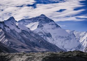
Mount Everest- Perhaps the mountains are a dream destination for the trekkers and adventurous. Being the world’s highest peak above 8000m, many mountaineers marked this place on their bucket list. The Mount Everest Base Camp Elevation is 5364m.
Similarly, the trekkers want to reach the base camp of this highest leak once in their lifetime.
People who wish to enjoy the picturesque natural scenery of the mountain, as well as the natural landscapes, can consider Everest Base Camp Trek for their upcoming trek.
Besides, the base camp even offers wonderful opportunities to explore the culture and local lifestyle over there.
As the lifestyle and culture of the Himalayan region of Nepal are similar to that of Tibet so, you can have a slight taste of Tibetan culture as well. Likewise, one can have a significant view of the entire Himalayan range.

Everest Base Camp Elevation
The Everest Base Camp Trek is a once-in-a-lifetime experience. In this trek, one can fully experience the sublimation of nature with the stunning view of the natural landscapes, icefalls, panoramic mountain views, and massive glaciers.
In an ideal world where people show interest in recreational activities, they would love to stand on the base camp of the world’s highest peak.
Generally, people with good physical fitness and a strong mentality can make it to the base camp of the world’s highest peak. And among all, the views from the Kala Patthar are the most spectacular.
- Stands at the base camp of the world’s highest peak at an elevation of 5364m.
- Witness the sunrise/sunset view from Kala Patthar, popular for the Everest viewpoint.
- A scenic flight to high altitude Hilary Tenzing airport at Lukla.
- Visit sherpa village and explore the culture which is similar to that of Tibet.
- Full-day exploration at Namche Bazar, the gateway to Everest Base camp trek.
- Visit Tengboche and Dingboche monasteries.
- Witness the stunning view of Khumbu Glacier and Khumbu Icefalls
- Pass through Sagarmatha National Park and explore the flora and fauna over there.
There are two base camps for the world’s highest peak, Everest. With its border between Nepal and Tibet, autonomous China, there are two major routes to the Base camp of Everest.
The southern route is Nepal whereas the Northern route is China. Similarly, the southern Base camp of Everest is Nepal whereas its northern base camp is in China.
Base camps are the campsites at the base of the mountain that is used by the climbers during their ascends and descends.
Mount Everest Details
Name: Mount Everest
Tibetian name: Chomolungma
Sanskrit name: Sagarmatha
Elevation: 8848.86m
Everest Base Camp Elevation: 5364m (17598 ft)
Location: Nepal-Tibet( an autonomous China) border
Temperature: -20 to -35 degree celsius
1st person to climb: Sir Edmund Hillary and Tenzing Norgay Sherpa
Summit wind speed: up to 280km/h average of 1 hurricane every four days
Facts of Mount Everest
- The tallest mountain in the world
- Around 4000 attempts to the summit
- The number of successful attempts is 660
- The death rate at the Everest summit 142
- Height of the Everest is 8848.86m
- Countries visible from the summit: Nepal, Tibet, and India
- Tibetian name Chomolungmas whereas Nepalese name is Sagarmatha
- The Everest is named for George Everest, a British surveyor- General of India.
- It is believed that Everest is approximately 60 million years old
- Sir Edmund Hillary and Tenzing Norgay reached the summit in 1953.
- Eleven people died during spring expeditions in 1996.
Everest Base Camp Elevation (South)
The southern base camp is at an altitude of 5364m in Nepal. When trekkers are climbing via the southern ridge, they use the south base camp.
South base camp has no proper access to road so supplies are shipped by porters, with the help of yaks.
The Everest Base Camp Trek on the south at an elevation of about 17,900 feet, is one of the most preferable routes for the trekkers.
More than 40000 people trek to the base camp every year. Trekkers usually fly from Kathmandu to Lukla and start their trek from Lukla to Namche Bazar, which is the gateway to the Everest Base Camp Trek.
Trekkers rest here for a day and trek for another two days to Dingboche monastery. Another two or three days take them to the base camp of Everest via Gorakshep.
Everest Base Camp Elevation (North)
If you want to visit the base camp from the north, you need a permit from the Chinese government and on top of the permit, you need to visit Tibet itself.
However, access to the north base camp has been closed to tourists since 2019. Earlier, Lhasa could arrange such permits via travel companies as a part of a package.
The north base camp is at an altitude of 5200m which can be easily accessible by bus or transportation.

Everest Base Camp Elevation in Meters and feet
The base camps to the world’s highest peak have the southern and northern sides.
The southern side of the base camp is in Nepal at an altitude of 5364m (17598 ft), similarly, the Northern side of the base camp is in Tibet which is at an altitude of 5150m (16900 ft).
Also, the southern base camp side is higher than that of the northern base camp side. Similarly, the southern base camp trek is popular among the trekkers where year 40000 trekkers make their trek to base camp from here.
On the other hand, the base camp trek in China is located about halfway between Rongbuk Monastery and Rongbuk glaciers.
Everest Base Camp Elevation Gain
There are a few major factors that trekkers need to consider before trekking to the Everest Base Camp Trek.
If you combine the daily walking distance, the weight you will carry on the trek, and the lack of oxygen in your body, then you will be able to implement a correct training plan for your trek.
Elevations gains are important to your training because by training you can make sure you are reaching these gains in your daily training.
Here is a short breakdown of the elevation gains for the base camp trek to the world’s highest peak.
Fly to Lukla
From Kathmandu, you will fly to Lukla airport. Lukla airport sits at an elevation of 2850m, (9350 ft).
From the elevation of 1350m, you will be at an elevation of around 2800m. So you will gain a relatively higher elevation.
From the airport, you will walk through the town and aim for Monjo but if we arrive late for the mountains we will rest at Phakding.
The walking distance for the trek is around 13 km. There are lots of steps up and downs in this part of the trail.
Namche Bazar
If you are trekking from Monjo, then you will start the hike with 2835m. Then you will gain an elevation of around 740m/2427ft uphill over a suspension bridge to Namche Bazaar.
The shorts downhill sections will take approximately. 4 hours to reach Namche. After crossing through Jarsalle and Sagarmatha National park you will descend to a hill over another suspension bridge and hike alongside the river and ascend to the suspension bridge.
From the bridge, it takes about two hours of walking up to the Namche. The walking distance for the trek is 8km.
Acclimatization Day
To adjust properly to the higher altitude we will have an acclimatization day in Namche Bazaar. A Namche is at an elevation of around 3500m, we will hike up to 120m to the Sherpa museum to acclimatize.
Furthermore, this is just a short 30 min hike. The team will enjoy the picturesque scenario from the museum for some hours and keep adapting to the lower level of oxygen.
Similarly, one can even hike up to 460m to Sangbouche hill. The hike is all about making your body get adjusted to the new environment and low level of oxygen.
Tengboche
Today we will hike from Namche Bazar and traverse the side of the mountain gaining an elevation of 260m/ 800ft. Then you will descend to 300m/984ft for lunch.
After lunch, the trekking is towards the Tengboche hill which is at600m/ 1968ft. It takes around 2 hours to get to Tengboche whereas the total day trekking time is 6 hours including ascends and descends.
This is another challenging trek for most people. The distance covered by the Trek is 12km.
Dingboche
Today we will reach a new elevation at 4410m/ 14470ft. Starting the trek with 4410m we will first descend 110m/ 360ft to the riverside, the trail ascends to 518m/1673ft.
The trail passes through Pangbouche and reaches Dingboche. The hike today takes about 6 hours covering a total distance of 12km.
Acclimatization Day
Then you will have 2 days of acclimatization day in Dingboche. Today hike up to 490m/ 1600ft, spend some time there and back down to the point where you have started from.
The trek takes about four hours and you will find that you are very close to the base camp. The mountains start to appear closer and in case of clear weather, you will be stunned by the view. Today, you will ascend to 3km.
Lobuche
Today you will hike up to 510m/1700ft. Starting with Lobuche, you will stop at Tukla for your early lunch. After lunch, start the uphill trek which approximately takes about an hour.
At the top of the Tukla pass, enjoy the break at the Everest Memorial. The incline is more uphill today. Likewise, the total hiking will be approximately 6 hours covering 12 km of the total distance.
Everest Base Camp -Gorak Shep
Today is the day to start your journey to the base camp. You will be at an elevation of 5364m. You will home up 400m/ 1300ft to the Everest Base camp. The trek will be longer today.
Similarly, leaving at 6 in the morning, you will be able to reach the base camp by 12 or 1 in the noon. Spend some time exploring the mountains over there.
Then, from the base camp, hike back to Gorak Shep. The distance for today’s trek is 10km.
Kala Patthar- Pheriche
Standing tall at Kalapatthar at an elevation of 5645m/ 18520ft, today is another special day for you. Waking up early, start the trek to Kala Patthar.
You will hike up 365m/1200ft at Kala Patthar. Then descend 1127m/3700ft to Pherchie. The distance covered by the trek is 18km.
Namche Bazaar
Hike down to 1000m/ 3280 ft to Namche Bazaar. The trek will be long today but will be easier because of the downhill.
Lukla
Then finally hike down to 700m/2296ft and up 365m/ 1200ft to Lukla.
Where is Everest Base Camp Located?
The world’s highest peak lies on the border of 2 different countries in Asia, Nepal, and China. It lies in the Mahalangur range of the Tibetian plateau known as Qing Zang Gaoyuan.
On the other hand, In Nepal, lies in the Sagarmatha National Park in the Solukhumbu district. So, climbers can have access to the summit of Everest from both Nepal and Tibet.
Yearly hundreds of people choose to summit Everest but very few get close to this almighty peak.
So, people choose to at least make their way to the base camp where few choose their trek from Nepal as half of them choose their trek from China, Tibet.
No matter where you decide to take the journey, the view offered from both sides is stunning and overwhelming.
Everest Base Camp is a lifelong destination for trekkers all around the world. The base camps are major campsites at the base of the mountains.
Many trekkers from all around the world who cannot make a summit to the peak directly tend to trek to the base camp. Thus, the base camp is the place from where the summit the peak begins.
Likewise, the world’s highest peak has a base camp in two bordering countries Nepal and China.
Nepal
Nepal is the sovereign country in South Asia covering an area of 147181 sq. km. Nepal is a landlocked country bordered by India in the east, south, and west and China in the North.
Nepal has a diverse geography and is a multi-ethnic country with Nepali as the official language. Nepal is home to 8 out of the world’s 10 tallest mountains including the world’s highest peak Mt. Everest.
Similarly, the basecamp to Everest is one of the most popular trekking activities in Nepal. Nepal is on the southern side of the base camp. The base camp in Nepal is at an altitude of 5364m (17598ft)
China
The other country that borders Everest is Tibet which is an autonomous region of China. The Tibetan name for Everest is Chomolungma.
China, officially the People’s Republic of China, is the most populous country with around 1.4 billion in the year 2019. It is the 3rd largest country in the world covering approximately 9.6 million sq. km.
However, the landscape of China is vast, and diverse ranging from the Gobi and Taklamakan Deserts in the arid north to the subtropical forests in the South. China is on the Northern side of the base camp.
The base camp in China is at an elevation of 5150m (16900ft).
Everest Base Camp Elevation Altitude Sickness
Altitude sickness is known as acute mountain sickness occurs when people have difficulty adapting to a higher altitude where the level of oxygen is extremely low.
Most cases of altitude sickness are mild that result in headaches, nausea, or dizziness. However, some people may face a fatal build-up of fluid that affects their brains and lungs.
Acute altitude sickness can start from an elevation of above 2500m above sea level.
Because of the risk of altitude sickness, humans need more time to acclimate themselves to a higher altitude. But because most of the travelers and trekkers are originally from lower altitudes.
So, they need some time to acclimate to the higher altitude. Altitude sickness can happen to anyone and at any time above 2500m. That’s why the human body needs physical and mental fitness while trekking to a high altitude.
Altitude Sickness on Northern And Southern Side
The base camps to the world’s highest peak, the southern and northern sides. The southern side of the basecamp is in Nepal at an altitude of 5364m (17598 ft).
Similarly, the Northern side of the base camp is in Tibet which is at an altitude of 5150m (16900 ft). The southern base camp side is higher than that of the northern base camp side.
Altitude sickness is a high-altitude area where the air is thin. If symptoms like nausea, vomiting fainting, rapid pulses, and extreme dehydration start showing you should immediately get medical help.
Everest Base Camp is a very joyous and adventurous trek but it is equally dangerous as well. A person who has never been to an altitude more than 2500m, should be concerned about altitude sickness.
As you go up higher, the vegetation starts to disappear slowly.
Trekkers will start their journey at 1350m at Kathmandu and fly to Lukla airport at an altitude of 2800m.
After Lukla, the trekkers have to pass through various places where the altitude is around 3800m, so there may be high chances of altitude sickness.
Here are some of the trek that has been tried by experienced trekkers mountaineers to minimize the risk of altitude is sickness they are:
Ascend Slowly
Our body needs some time to adjust to the new environment, therefore, walking slowly or ascending slowly helps the trekkers to get their bodies to acclimate.
Proper Acclimatization Rest
Trek to a higher altitude must have two days of acclimatization day so that one can adjust to the surrounding environment. During accommodation day one can trek as high as they can and return to the lower altitude.
This will keep your body get used to the new environment and minimize the risk of altitude sickness.
Avoid Alcohol Cigarettes and Tobacco
Trekkers have to walk uphill and downhill in the Everest base camp which needs enormous physical fitness.
However, consumption of alcohol, cigarettes, and tobacco can decrease water levels in the body and make you dehydrated. So it makes your heart slow and leads you to get caught by altitude sickness.
Keep Yourself Hydrated
Keeping yourself hydrated is one of the best ways to minimize altitude sickness at higher altitudes. Water is the best remedy. It is recommended to hydrate your body with 500ml every half an hour while trekking.
Eat Well and Plenty
Lots of people lose their appetite during the high-altitude trek. Losing appetite means constantly keeping your body weak.
Eat liquid food more and having good food will increase your stamina which decreases the chances of altitude sickness.
Be Physically and Mentally Prepared
Above all, you need to be physically and mentally prepared for the base camp trek. Your body is not used to the higher altitude. So keep the consequences and start trekking.
Avoid negative thinking and enjoy the stunning scenario that the mountains offer.
Everest Base Camp Elevation with Trekking Itinerary
Everest base camp is one of the dream destinations for trekkers all around the world. It is an ideal destination for those who want to enjoy nature and natural resources.
The base camps to the world’s highest peak, the southern and northern sides. The southern side of the base camp is in Nepal at an altitude of 5364m (17598 ft).
Similarly, the Northern side of the base camp is in Tibet which is at an altitude of 5150m (16900 ft).
Itinerary to the Everest Base Camp from the south
Day 1: Arrival in Kathmandu
Day 2: Kathmandu sightseeing
Day 3: Fly from Kathmandu to Lukla, trek to Phakding
Day 4: Phakding to Namche Bazar
Day 5: Acclimatization day at Namche
Day 6: Namche Bazaar to Tengboche
Day 7: Tengboche to Dingboche
Day 8: Acclimatization at Dingboche
Day 9: Dingboche to Duglha
Day 10: Duglha to Lobuche
Day 11: Lobuche to Gorak Shep, visit Everest base camp
Day 12: Gorak Shep to Kala Patthar to Pheriche
Day 13: Pheriche to Namche Bazar
Day 14: Namche Bazaar to Lukl
Day 15: Fly to Kathmandu
Day 16: Final Departure
Please visit here for the detailed itinerary.
The base camp to Everest is one of the most popular trekking destinations in Nepal. Many of the trekkers have set their eyes on the Everest Base Camp Trek.
The base call to Everest provides a wonderful opportunity to explore the Himalayan region of Nepal as well as witness the Buddhist culture and monasteries.
For those who want to explore nature and natural resources, the Everest base camp trek is one of the best destinations for them.
On the base camp of the world’s highest peak, we experience astonishing mountains, get a glimpse of the mountain life of Nepal, enter Sagarmatha National park, visit Buddhist heritage sites as well as get a closet of Tibetan culture, and tradition.
You will pass through various places such as Namche Bazaar, Tengboche, Dingboche, Duglha, Lobuche, etc.
Get a stunning view of the Himalayan area and natural landscapes from Kala Patthar. Stand tall at an elevation of 5364m, and get close to Everest.